Saturday, August 10, 2013

SIQUIJOR ISLAND

Location: Central Visayas, Philippines
Region: VII
Coordinates: 9012’N 1230 30’E
Total Land Area: 343.5 km2(132.6 sq mi.)
Capital: Municipality of Siquijor
Founded: September 17, 1971
Component Cities: 0
Municipalities: 6
Barangays: 134
Districts: 1
Time Zone: PHT (UTC+8)
Zip Code: 6225 - 6230
Dialing Code: 35

Blogger’s Note: The small island of Siquijor which is considered as the third smallest province of the Philippines has six (6) municipalities, namely: Enrile Villanueva, Larena, Lazi, Maria, San Juan and Siquijor.

View Siquijor in a larger map


St. Isidore de Labrador Church in Brgy. Catamboan, Lazi, Siquijor or simply known as Lazi Church built in 1884 through the supervision of the Recollects priests


Siquijor at a closer glimpse is an island full of charm with its tranquil and endless coastal beaches. It is just an hour travel through ferry from Dumaguete City. It is just a continuation of our Bohol and Cebu trips The first time I visited it wayback 1998, through a four-island (Cebu, Bohol, Dumaguete and Siquijor) tour package which I organized it by myself, was that, I was occupied with the idea of witchcraft which the place has been noted for. But my recent travel there turned out to be so successful and enjoyable one. Gone were the days filled where I was filled with so much pessimism about the place. My group instead has traveled around the island without any trace of hesitation. What we had in our mind was to maximize the tourist spots we might visit in this beautiful idyllic island.

The interior of St. Isidore de Labrador Church


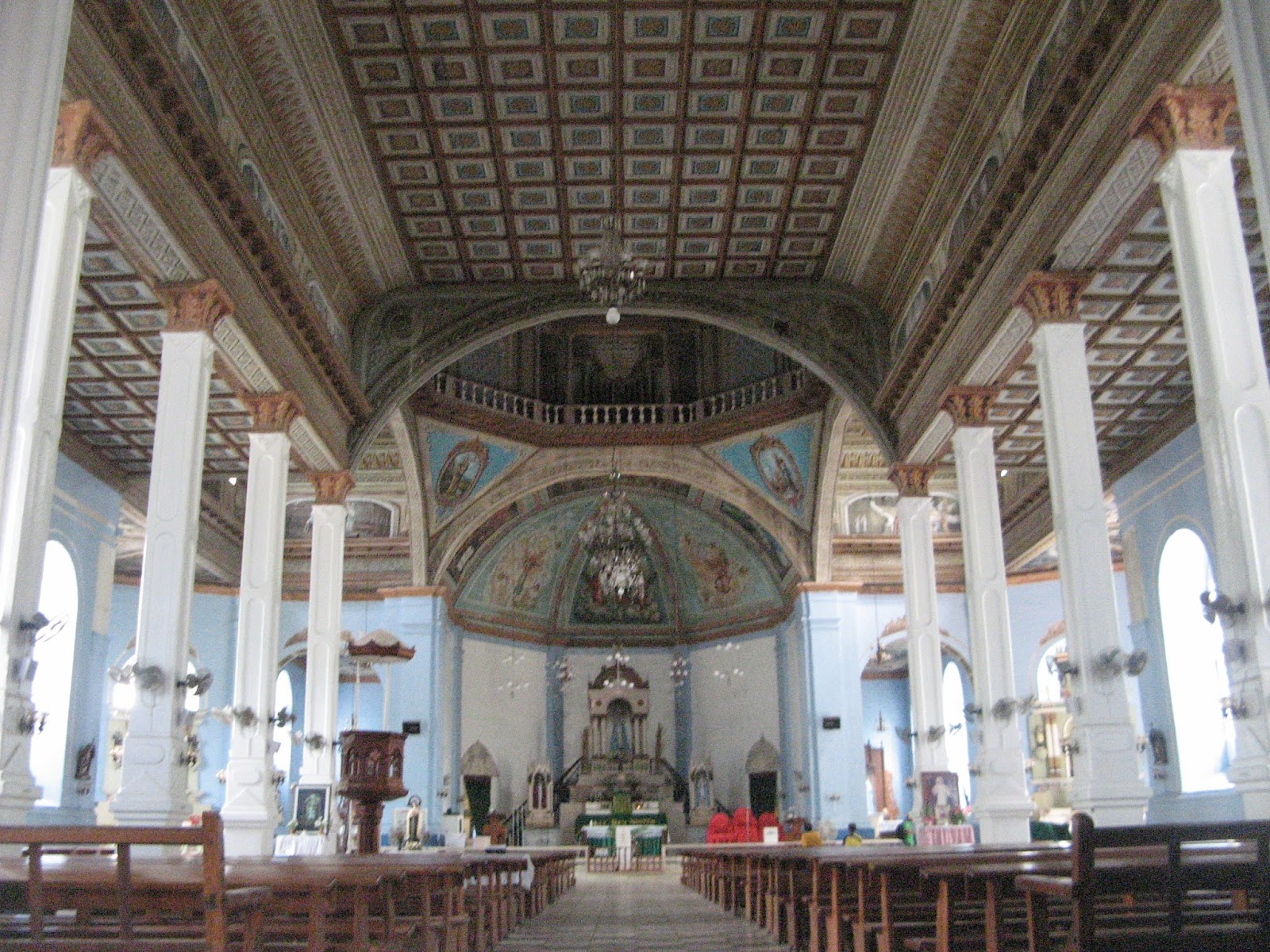
It is surprising to see such a creative architectural design like this of St. Isidore de Labrador Church. Across is the Lazi Convent, which is said to be the biggest convent in Asia completed by Filipino artisans in 1884. Both the Lazi Church and the convent was declared as National Historical Shrines and are being maintained now by the local government.

The altar of St. Isidore de Labrador Church


St. Isidore de Labrador Church and its convent is just 15 kilometers away from the town of Lazi. It is very interesting to tour inside the two majestic structures for it will reveal what life was during its glorious days.

Lazi Convent - the biggest convent in Asia


Recalling the trip, we first landed in Siquijor Port and just a few meters away, one can see the laid back town and a few stores which offers basic commodities. Then from there, we visited the Saint Francis of Assissi Church.

Saint Francis of Assissi Parish Church built on February 1, 1783 by the Franciscan priests


Siquijor Port is in the Municipality of Siquijor province and Saint Francis of Assissi Church is a part of this municipality. After a short prayer inside the church and a quick tour around the town and the church's vicinity, we headed to the municipality of San Juan.

Part of Capilay's Spring Park


This natural spring park is very accessible for it is located at the heart of the town and is open to everyone for free. It is consist of three main areas, namely: the upper pool, the swimming pool and the laundry pool where it all empty to the nearby sea. To complete the fun, the local government has equipped the park with a playground, booths, and kiosks to cater for the needs of visitors most particularly the bigger groups and for family functions.

The Creepy 400-Year Old Balete (Dalaquit) Tree


Driving further had led us to the enchanted 400-year old Balete Tree in Barangay Campalanas, Lazi Municipality.

The cascading Cambugahay Water Falls


This water falls is just two kilometers north from the town of Lazi nestled in a forested area consisting of cascading multi-tiered waterfalls coming from a collection of water sheds from the neighboring mountains, natural springs and small rain forests which empties to Lazi Bay.

While waiting for a sumptuous lunch at the picturesque Larena Triad Cafe


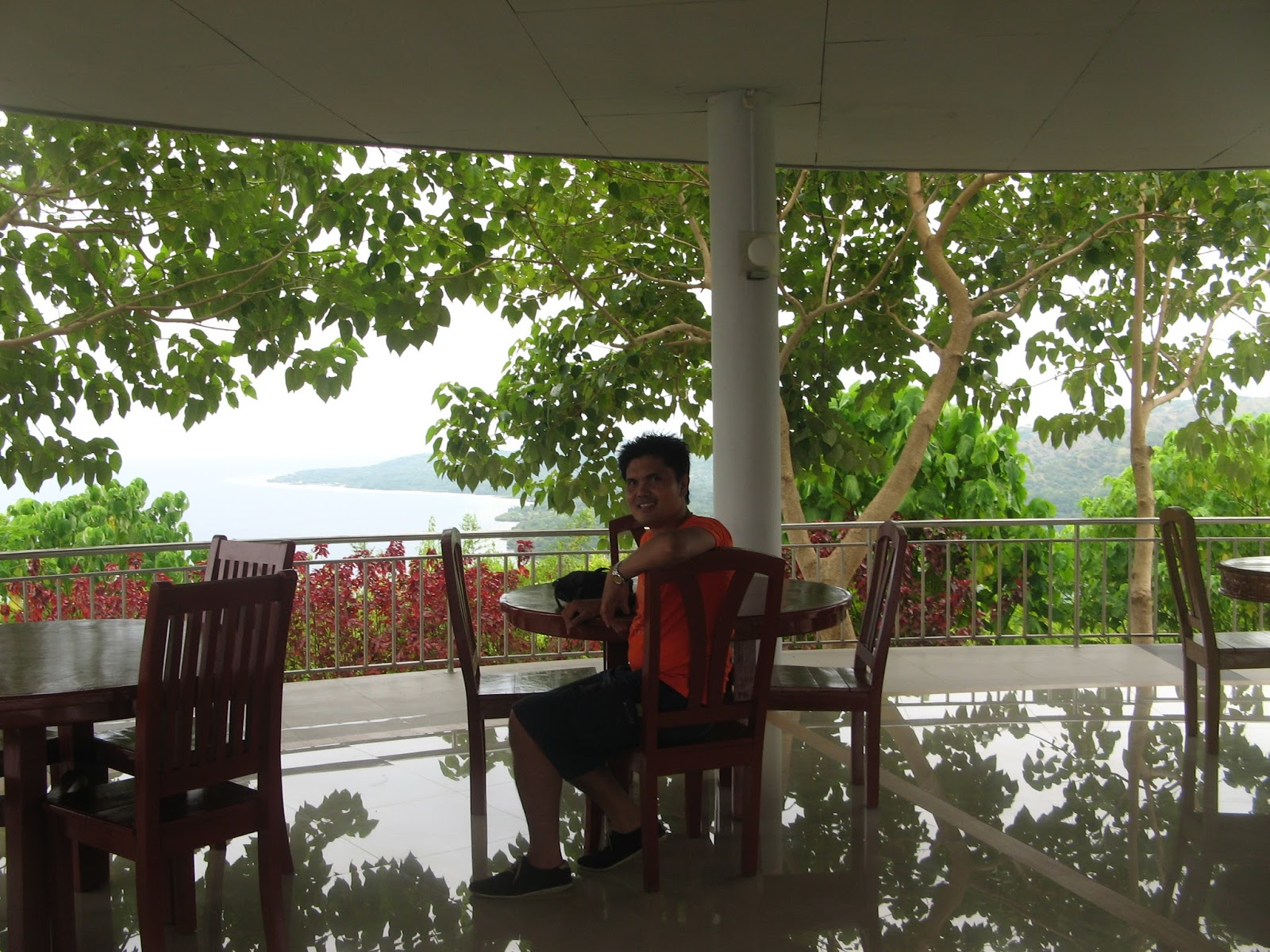
The scenery on top of Larena Triad Cafe is just so spectacular most particularly during sunset. Staying at the cafe is so refreshing not only with the food that it serves but most particularly with the fresh air that you breathe and the high definition colors of the skies, far sea and the rich green down the hills.

The spectacular view from the top of Larena Triad Cafe


Taken at the Cantabon Cave during my first visit in Siquijor

Scaling Mount Bandilaan National Park

Check on the links for other tourist spots to visit in Siquijor as follows:

Siquijor Butterfly Sanctuary
Paliton Beach and nearby hotels and resorts
Hotel Agripino and Salagdong Beach
Salagdong Forest Reserve
Bulalakaw Forest Reservation
Mount Bandilaan National Park
Kagusuan Beach
Guiwanon Spring Park
Tulapos Marine Sanctuary
Cang-isok House
Our Lady of Divine Providence
Eugenia Cave

HOW TO GET THERE

From Manila to Siquijor

Budget airlines like Cebu Pacific have daily flights to Dumaguete City of Negros Oriental for an hour travel
From Dumaguete City Airport (Sibulan Airport), you can charter a tricycle going to Dumaguete Port
From Dumaguete Port, you can have a choice of a ferry where you can board to Siquijor for an hour trip

From Cebu City to Siquijor

From Cebu City, take a bus bound to Liloan, southern part of Cebu Province, from its South Bus Terminal. Travel time varies from 2.5 to 5 hours depending on the traffic conditions.
From Liloan Port (Cebu), take a ferry to Sibulan, Negros Oriental, with a separate charge on the terminal fee for about 30 minutes
From Sibulan Port, take a jeepney for Dumaguete City
From Dumaguete City, take a ferry of your choice which will take you to Siquijor for an hour travel

Sunday, August 4, 2013

BOHOL PROVINCE

Location: Central Visayas, Philippines
Coordinates: 090 50’N 1240 10’E
Total Land Area: 4,820.95 km2(1,861.38 sq mi.)
Capital: Tagbilaran City
Founded: March 25, 1565
Divisions
Component Cities: 1
Municipalities: 47
Barangays: 1,109
Districts: 3
Time Zone: PHT (UTC+8)
Zip Code: 6300 - 6346
Dialing Code: 38

Blogger’s Note: Bohol is popularly known for its chocolate hills and tarsiers. It is also the place where the first international treaty of friendship known as "sandugo" was held in 1565 between Datu Sikatuna, a chieftain in Bohol and Spanish conquistador Miguel Lopez de Legazpi.


View Bohol in a larger map


Chocolate Hills in Carmen, Bohol


Bohol is just an average of one hour and 40 minutes from Cebu City to Tagbilaran by fast sea ferries like Ocean Jet and Weesam Express. The place has a unique beauty of its own. With a lot of tour operators now competing for a good catch of clientele, tours to Bohol in particular is now becoming affordable. You may try to get your package from this link Bohol Tours and Packages

Tagbilaran Church or presently known as Cathedral Parish of Saint Joseph The Worker


The interior of Dauis Church of Panglao Island


Bohol is noted for having a number of old churches with unique and artistic architectural designs.In fact, The Baclayon Church, which is just six kilometers away from Tagbilaran City is the second oldest stone church in the Philippines next to San Agustin Church, in Real Street, Intramuros, Manila, built in 1571. Baclayon was constructed in 1595 by the Jesuit priests, it is still intact and houses important relics and images reminiscent of the historic Roman Catholic religion in the country.

Front view of Baclayon Church or presently known as Church of Immaculate Conception


The interior of Baclayon Church


Tarsier watching in Vilar


Just about to board the Loboc River cruise


The Loboc River cruise


Festive lunch while on board the river cruise


Saturday, August 3, 2013

CEBU CITY AND NEIGHBORING CITIES

Location: Cebu Province, Philippines
Coordinates: 100 17’N 1230 54’E
Total Land Area: 315.0 km2 (121.6 sq mi)
Metro Land Area: 1,163.36 km2(449.18 sq mi)
No. of Districts: 2 (South and North)
No. of Barangays: 80
Time Zone: PST (UTC+8)
Zip Code: 6000
Dialing Code: 32
Legal Class: Highly urbanized City
Income Class: First Class

Blogger’s Note: Cebu City is popular for its festival called Sinulog held every third Sunday of January which commemorates the Filipino people's pagan origin, and their acceptance of Roman Catholicism.

View Cebu City in a larger map


Part of the Basicilica del Sto. Nino


Cebu City is the oldest city in the Philippines which was established as the first settlement of the Spaniards who colonized the Philippines for 333 years. Its strategic location and deep sea ports makes it the country’s main domestic shipping port. It is considered to be the second most important metropolitan area and also second most populous city in the Philippines after its capital, Metropolitan Manila. click here for hotel bookings and learn more about Cebu City by reading this link

This Sinulog photo is owned by this link which is the grandest of all Philippine festivals


Main entrance of Shangri-La Mactan Resort and Hotel


Flying to Cebu City touches down in Mactan International Airport of Mactan Island. This island prides itself its world class beaches in terms of amenities and facilities where one of it is the Shangri-La Resort and Hotel. Another is the Cebu Beach Club, Maribago Bluewater Beach Resort and you can also visit the nearby paradise-like top 7 resorts in the province of Cebu. All these can be enjoyed by you in just a short span of time.

The historical Lapu-lapu Shrine of Mactan where Lapu-lapu killed Magellan


From the airport, one can drive thru Lapu-lapu and visit the miraculous Virgen de la Regla.. To continue the drive, you will pass thru Mandaue City Hall, National Shrine of Saint Joseph Mandaue and Cebu International Convention Center.

Mandaue City Hall


Saint Joseph National Shrine of Mandaue


Part of the Ayala Center of Cebu City


The Malacanang Palace of the South


The historical Fort San Pedro


Touring around Cebu City minus the beach swim or hopping would only need at least a day including buying souvenir items. Food and delicacies are served in some of its carenderias, restaurants and hotel dining. Important tourist spots in Cebu City are: Cebu Heritage Monument Park of Parian, Cebu Metropolitan Cathedral, Magellan's Cross, Cebu Taoist Temple and Basilica del Santo Nino

The South Road Development Properties


Much has been invested on the southern part of the city as operated and managed by the South Road Properties where your can see various images in this link. When completed, Cebu City will be turned into one of the most important cities in Asia. To know more about the South Road Properties, you may click this link.
Refreshing along the poolside of Marco Polo Hotel at 600 feet elevation overlooking Cebu City


Late afternoon is the best time to spend time along the poolside of Marco Polo Hotel formerly Cebu Plaza Hotel located in the scenic Nivel Hills 600 feet above sea level. It offers a 360% scenery of the whole city of Cebu. Read and learn more about the hotel by clicking this link, Marco Polo Hotel. Read this link to learn how to travel within Cebu City and going out from Cebu to its neighboring islands.

Sunday, July 21, 2013

CALAGUAS ISLAND

CALAGUAS ISLAND

Location: Vinzons and Paracale, Camarines Norte, Bicol Region, Philippines
Coordinates: : 14°27N, 122°55E
Total Area: (not available in Wikipedia)
Blogger’s Note: Calaguas, is a group of more than 20 islands and islets which include the three major islands, namely: Tinaga, Guintinua and Maculabo where it has three barangays in the name of Banocboc, Pinagtigasan and Mangcawayan. The famous Mahabang Buhangin is located in Barangay Mangcawayan of Tinaga Island, the largest of Calaguas group of islands about eight kilometers long; Guintinua Island at six and half kilometers long and Maculabo at about four kilometers long.


View Calagua Islands in a larger map


The very relaxing sight of the paradise white sand of Mahabang Buhangin


The undisturbed beauty of the famous Mahabang Buhanging Beach located on the northern part of Barangay Mangcawayan, Tinaga Island, Municipality of Vinzons, Camarines Norte. "Mahabang Buhangin" literally means "long beach". Calaguas Island tops among the TOP TEN TOURIST GEMS of the Philippines as shown is this link.

The cottages for rent of Kagedama Properties


Tourists of the island can have an option whether to rent smaller cottages for P300 or the bigger ones at P500 of Kagedama properites. They can also have their tents but an island entrance fee of P170 is imposed inclusive of the water consumption for shower, food preparation and comfort rooms.

Newly constructed bigger and comfortable cottages at P3,500 rate per day


Unlike before that Calaguas stay offers no cottages to stay with, this time, cottages of different sizes and prices are already at your pick. There is already a supply of electricity and even stores where you can buy cold drinks.

These newly constructed big cottages are next to Kagedama cottages


Along the beach coast is dotted with coconut trees where you can buy buco fruit anytime you want from the enterprising caretakers of the cottages. You can even buy newly caught fish early in the morning from fishermen who also serve as caretakers of the cottages around.

Aerial view of Mahabang Buhangin


Trekkers and hikers will also love to scale the other side of the beach and on its peak is a rewarding scenery of the surrounding seas, islands, islets and the Poblacion, the barangay proper of Barangay Mangkawayan. It can be done in an hour or two.

Cleanliness is observed in the beach and its premises


Locals, NGOs and other tour operators are jointly imposing the rules of order and cleanliness in the island to make it the best for all tourists and guests.

The beach is quite enticing and inviting to swim and dip endlessly


The soft and powdery white sand of the coastline can also be felt by the sole of your feet when one walks through the seabed. No sharp shells. Seawater is not so salty and so it is friendly to your eyes when you take a dive. The deepness of water is so gradual and that you can swim a few meters from the coastline.

This sunset scenery of Mahabang Buhangin was taken by Jorge Cabrera


Sunset and sunrise are both magnificent in Calaguas. The serenity of the place adds up a meditative aura for people who like to put themselves in complete contemplation with mother nature.

Last glimpse of Mahabang Buhangin while on board of our chartered boat


As we boarded the boat away from Mahabang Buhangin, I felt a sense of urgency to promise to myself that I have to return to this place and even stay longer to maximize enjoyment.

Dropping by at the Maculabo Island


We are suppose to drop by both in Guintinua and Maculabo Islands but the boatman had deceived us thus only reaching the Maculabo Island after a 40-minute sea travel and another 25 minutes going back to Paracale Port.

For those who wanted tour package for their Calaguas trip, You can check this!

How to get there in Calaguas? You can check this!

Wednesday, July 10, 2013

BIRI ROCK FORMATIONS


BIRI ISLAND

Location: Municipality of Biri, Northern Samar, Philippines
Municipality Type: Class 5
Coordinates: 12°40"N, 124°23E
Total Area: 24.62 Square KM (9.51 square miles)
Blogger's Note: Biri is consist of several islands where other bigger islands are: Talisay, Magesang and Cagnipa. It is facing Pacific Ocean. Rock formations can be found in islets close to Biri Island, namely: Magasang, Magsapad, Macadlaw, Puhunan, Bel-at and Caranas. Geron is a surfing area of the island. Biri Island ranks 5th among the TOP TEN "TOURIST GEMS" of the Philippines as shown is this link.
Electricity Supply: It is available from 12:00 Noon till 12:00 midnight only but the surrounding islands do not have electric power supply. Know more about other accommodation

View Biri Islandin a larger map


I traveled to Biri Island by Southroad (or simply by land) through Philtranco airconditioned bus for P990 which left its Pasay Terminal at 11:00 A.M. and arrived in Matnog Port of Sorsogon Province at 3:30 A.M. (dawn) the following day which sums up to 16.5 hours of bus travel from Pasay City to Matnog. It took us 75 minutes at P120 to cross the San Bernardino Strait from Matnog Port to Allen Port of Northern Samar. We took a 12-minute ride of a pedicab at P20 from Allen Port to Jeepney Terminal with a signboard of Catarman. Though, we only have to drop in Lavezares at P15 which took us for 15 minutes only.


From Lavezares Port, we chartered a boat for P150 each with a capacity of 5 persons going to Palhugan Port of Biri Island which was for 58 minutes or one hour to be exact. It was such a refreshing morning and just around 20 minutes boarding the boat, we passed through the image of the Virgin Mary as shown in the photo above.


As we continue our boat travel, we saw at a distance through the clear morning skies Mount Mayon Volcano on its majestic and imposing perfect cone. After all, Samar is just near Albay divided by the San Bernardino Strait.


Now, we are approaching Biri Island with so much excitement seeing at a distance the Palhugan Port. It’s a typical island with hospitable folks and bystander teenagers greeting us with a good morning.


Entering the gate of our Biri accommodation, the Villa Amor --- new, clean and affordable and maybe one of the best in the island.


The roofdeck of our accommodation which is just a 10-minute habal-habal (single motorcycle) ride for P20 at Villa Amor offers such a 360 degrees scenery showcasing most part of the scenic beaches.


The bridge going to Magasang rock formation which is just a 15-minute habal-habal ride from Barangay Poblacion of Biri for P60 for a maximum of 3 persons in one habal-habal or P20 per head (roundtrip).


Approaching the Magasang rock formation after crossing the concrete bridge. The trail is rocky and wet and at some point you have to walk through shallow water.


This is a part of the Magasang rock formation. Just part of the famous Biri Rock formations.


This is still a part of Magasang rock formation. You can climb the rock formation with caution as some part of it are wet and mossy.


After spending ample time at Magasang rock formation we left and at a distance I took another farewell shot as if I do not like to leave the place. So amazing.


Far from the shore, we can see another destination. However, we need to ride in a habal-habal to get there. Thus, we took a very distant shot of Bel-at rock formation while boarding habal-habal.


The long and winding boardwalk going to Bel-at rock formation. One roundtrip of habal-habal going to Bel-at is a maximum of three persons for P45 or P15 per person.


Down the long and winding boardwalk going to Bel-at rock formation is a marsh and swampy area with mangroves abound.


Approaching Bel-at rock formation after crossing the long and winding boardwalk. Bel-at is another islet with massive rock formations.


Relaxing under a massive rock formation at Bel-at rock formation. Next to his is a crystal-clear pond with fishes abound.


Climbing through the delicate part of Bel-at rock formations. It was so risky since one false move may mean piercing your skin with sharp rocks.

An aerial shot taken while at Bel-at rock formations.


After a tour in Magasang and Bel-at rock formations, I had an afternoon walk along the port in Brgy. Poblacion.


After a long afternoon walk, we returned back to our accommodation in Villa Amor and enjoyed the amazing scenery on its roofdeck with cold drinks, cakes and pastries.


The air at the roofdeck was soothingly cool and it was inviting to sleep there. While we were relaxing, we were listening to the pipe-in music until such time that we forgot everything and finally slept. It was already 6:30 P.M. when I woke up and proceed to my room.


Fresh in the morning, I stayed outside my room to savor the refreshing sea breeze just after the breakfast. All guests of Villa Amor were busy preparing for their activities for the day and that included me.


My group has no idea of what is the best destination next in our trip and activities for the day. We went to the Tourism Office in Poblacion just opposite the Catholic church and we were told to try Punta rock formations. With this, we hired a habal-habal being three only in the group and headed to the place. The photo above shows the entry to Punta rock formations.


Surprisingly, what I enjoyed in Punta rock formations are not really the rock formations but rather the big and geyser-like water formation where the seawater ejected spouts upward and down to the rocks. The waves were playful enough to give our digicam the opportunity to capture good shots with them as our background.


After having lunch in poblacion of the town of Biri, we headed to this verdant and aqua-marine blue beach coast in the island of Suliran which is just a 10-minute boat ride from Palhugan Port. This is uninhabited and undisturbed since there is no beach resort yet erected here. But mind you, being here offers a total privacy and one can even go naked if he wants. The rich background of trees is a part of Cagmanipis Island.


Part of Cagmanipis Island just across Suliran Island for around five minutes away. It has rich mangrove sanctuary. Like Suliran island, Cagmanipis is grown with coconut trees and can be a great source of buco fruit. In fact, our local guide harvested some for us for free.


Walking around Cagmanipis Island, one can see the rich biodiversity of mangrove aquatic life and various small species of fish can be seen thriving inside the roots of mangroves. The beach front of the island has strong current and may not be ideal for kids for swimming.