Saturday, July 19, 2014

UGANDA WORK TRAVEL

Location: Uganda, East Africa
Total Land Area: 241,038 sq. km. (146,670 sq. mi.)
Elevation: Average of 1,100 from sea level (3,609 ft.)
Capital City: Kampala
Official Languages: English and Swahili
Independence from the UK: October 9, 1962
Currency: Ugandan Shilling (USh)
Time Zone: EAT (UTC+3)
Calling Code: +256
Descriptive Summary: Uganda is a landlocked country in East Africa. Uganda takes its name from the Buganda kingdom, which encompasses a large portion of the south of the country including the capital Kampala. Beginning in the late 1800s, the area was ruled as a colony by the British, who established administrative law across the territory. Uganda gained independence from Britain on 9 October 1962.


Part of home visitation to our village bank’s clients


My VSO volunteering work in Uganda wayback June 2002 to September 2003 will always be one of my best experiences where I lived in Africa for 14 months working as a Programme Management Advisor specializing in village banking operation managing a village bank in the name of When Rains Fail Trust (WRAF).

My VSO Uganda Batchmates


VSO which stands for Volunteer Service Overseas is the largest international volunteer sending organization since 1958 based in London with 76 beneficiary countries. I was recruited in the Philippines by the VSO Bahaginan Organization. I had eight batch mates when I arrived in Uganda on June 21, 2002 in the names of Jamie Alan Breadmore (Canadian), Murad Ahmed Hassen (Canadian), Isha Tan (Canadian), Dr. Kate Hulbert (British), Dr. John Ellis (Irish), Ali Alidina (Canadian), Stefan Vincent Quinton Kloop (Canadian) and Dr. Alastair James Watt (British). We were then 74 foreign volunteers of different nationalities working in Uganda by that time. Our batch then was welcomed with a Barbecue Night hosted by VSO Ugand Office.

VSO Development Education Field Day Visit in Nyakalengijo Village in Kasese


Aside from my main job as a programme management village consultant, I had always attended to VSO monthly development education visits to other parts of the country to monitor the sustainability of the beneficiaries of the community and conservation development programme implemented in every locality.

The usual bonding with my village bank clients during evening tea breaks


Ugandans are very hospitable people. They gave high respect to the “Muzungus” like me. Muzungu is a term for non-black foreign volunteers working in Uganda. What I like most in Uganda is the cold climate being a land of high elevation with a weather pattern uniquely cold contributed by Lake Victoria, one of the biggest lakes in the world.

Part of my daily routine of evening walk


In Uganda, the sun usually sets at almost 7:00 P.M. and so evening walks are still provided with broad day light. The village where I live is so green and vegetables and fruits are very cheap such as: avocado, papaya, pineapple, water melon, jackfruit, banana, Irish potatoes (patatas in the Philippines), sweet potatoes (camote in the Philippines), eggplant and cabbages. Their jackfruit are huge and they have the best avocado in the world. I can still remember that few of my clients would normally give me a sack or two of avocado and huge jackfruit when they apply for a loan from our bank where they use the proceeds to buy tea leaves from tea farmers.

Clad in a Ugandan National costume


By the time, I was in Uganda their currency exchange rate to one (1) US Dollar was 2,200 Ugandan Shillings (USh). An ordinary Ugandan citizen should have at least USh100,000 for their monthly income to survive. A kilo of a beef’s meat costs USh4,000; Pork at USh5,000 and Chicken at USh8,000. In the villages, there is no water supply coming from commercialized water suppliers and so one has the option to buy it from the enterprising kids who get the water from a hill’s base coming from a spring source about 4 kilometers away for each one jerrican (water can) at USh800.

Muhwezi Amos Katubiri standing infront of my accommodation atop the hill


My work placement was based in Nyakashaka Village, Burere sub-county, Buhweju county, Bushenyi District, Uganda, East Africa. It is 7 hours bus travel from the capital city of Kampala along national tarred road and another two (2) hours taxi travel from the national road to Nyakashaka trailing a very dusty road. Dry red loose soil are blown up into the air whenever vehicles and tea trucks pass resulting for fine dust to penetrate inside leaving all the passengers red-dust covered. Taxis in Ugandan village parlance, are old five-passenger cars but which is being jam-packed with at least twelve passengers along with their cargoes with a fare of USh8,000.

My Canadian programme officer and colleagues at WRAF


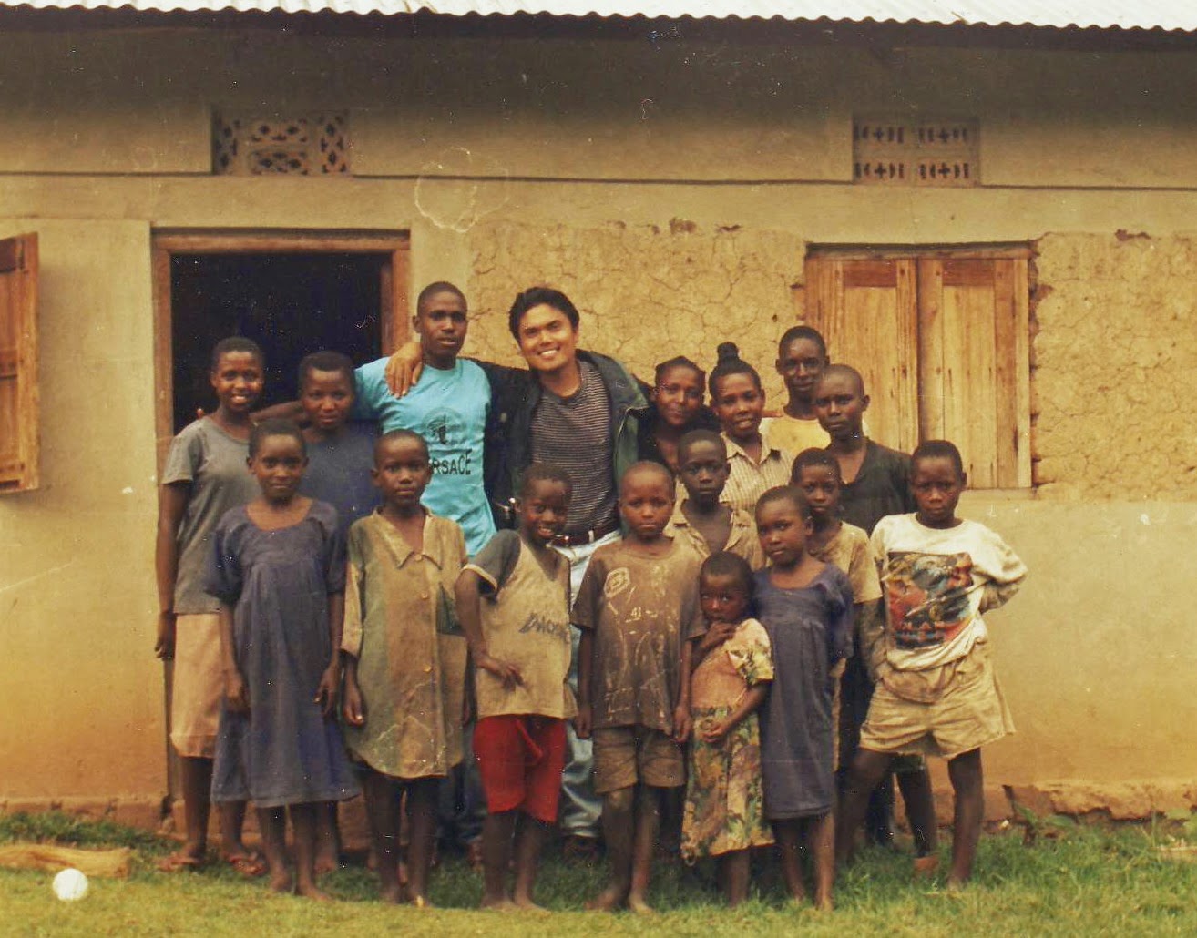
I was directly reporting to my programme officer in the name of David Gamey and my Ugandan counterpart was Mr. Winnington Kano Naijuka Kekurutso (in red polo shirt in the picture). The only lady in the picture is Miss Barbara Kasange Murungi, the branch manager of the Nyakashaka branch since we had operated three branches then.

Part of the sensitization activities


The objective of VSO is to help any beneficiary community to train my counterpart and his whole team and transfer any form of knowledge and technology for sustainability. Thus, I was faced with the gargantuan task of training the village bank team in the aspects of savings generation, accounting, auditing, loans operations, personnel management, policy formulation, staff and members training and marketing. I also conducted bookkeeping training to member entrepreneurs whom we extended revolving credit fund (RCF) as “hotel” operators in the nearby villages. Hotels there are just small stores offering tea and matoke (boiled mashed banana as staple food).

WRAF’s service car for official trips


Life in my placement has so much community exposure as we travel from one village to another to have the sensitization activities of the bank. The locals are very happy when you greet them in their Runyankore language with: “Agandi, banyabo na basebo” which means in English as “A pleasant day to you, ladies and gentlemen.” Or “Nashemererwa, munonga mononga!” which means that “I am very much pleased to be with you all!”

Another option of service vehicle


Not all roads leading to the isolated villages are passable by car. The only option to travel is to use a Yamaha 125 Single Motor Vehicle.

My English and Math students in Rwibaare Village


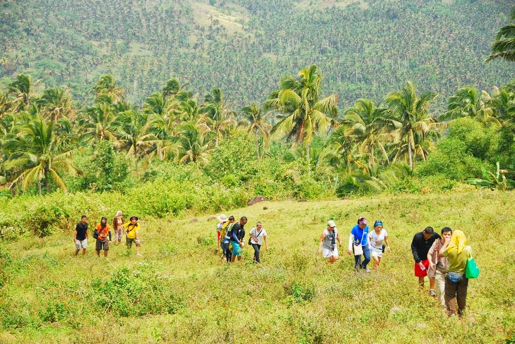
After five months of stay in my Ugandan placement, I realized I had so much spare time. That was the time I started to volunteer teaching English and Mathematics subject during weekends in nearby villages of Rwibaare, Kakindo and Ryamasa. Teaching was not a part of my placement pack (job description). In return, my students would usually guide me to scale the nearby mountains like the Mount Kyangenyi. Lawrence Sajja (in blue shirt in the picture) is my permanent guide.

While at the summit of Mount Kyangenyi


While I enjoyed so much my volunteering work in Uganda, I also enjoyed so much the mountain climbing and photography in my placement base. I was lucky to have such a picturesque place with a cold climate. In most cases, thick fogs can be experienced and there is zero visibility. My place is even colder compared to Sagada in the Mountain Province of the Philippines which is considered the coldest in the country.

My friends at the shoulder of Mount Nyakarangara


Mount Nyakarangara is the nearest mountain to my work placement. This is the usual place where I take my visitors for a climb like the couple Grant Gilbertson (British) and Dr. Patricia Tivadar (Romanian) and Behram Darruwala (Indian).

Aerial view of the Royal Circuit Tract at Queen Elizabeth National Park


Aside from my usual travels to the nearby villages, I also had major travels and one of the most memorable was when I visited the wilderness of the Queen Elizabeth National Park which is five hours drive away from my placement post.

The Mweya Lodge in Queen Elizabeth National Park


Queen Elizabeth National Park is a natural savanna game reserve where lions, elephants, baboons, hippos, Ugandan kobs, water bucks, antelopes, buffalos, bush pigs, colobus monkeys, Egyptian goose, black-headed gonolek birds, serval cats and many others are just a common sight.

The equator marker at the Kasese District


On our way to the Queen Elizabeth National Park, we happened to pass through the equator marker located in Kasese District. The whole national park is in Kasese District.

The Speke Camp at the Bujagali Falls


I also travelled to the Bujagali Falls which is a part of the Source of the Nile River located in the town of Jinja. In the same event, I had a cruise to the Source of the Nile going to Lake Victoria and passed through an island marker where Nile River and Lake Victoria meet. In a separate occasion, I had the opportunity to have a day-long white water rafting along the Nile River and eve prior to the rafting was a Barbecue night of all the guests.

While at a Lake Bunyonyi Trip


Lake Bunyonyi is the deepest lake in Uganda which has 39 islands of which Bushara Island at area of 16 hectares is the most well developed equipped with modern facilities and lots of amenities to enjoy.

Indeed, it is worth to be A VOLUNTEER! With this, I encourage each and everyone of you to do your part in SHARING SKILLS, CHANGING LIVES of others, that is VSO’s motto.

Thursday, July 17, 2014

SACRED HEART RETREAT HOUSE AND SEMINAR CENTER

Location: 1117 Quirino Highway, Novaliches, Quezon City, Philippines
Telephone Numbers: (02) 939-5060/69
Mobile Phone Number: (+63) 917-8688187
E-mail Address: shretreat@yahoo.com
Website: www.shretreat.com
Descriptive Summary: Sacred Heart Novitiate Retreat House and Seminar Center is owned and managed by the Jesuits which has been operating for 75 years already and considered to be their spiritual home and countless others opted to be in warm embrace of God’s divine presence. It has four air-conditioned rooms which can accommodate 30 to 150 people. It also has seven private rooms for individual consultations and spiritual direction. It was the Jesuit missionaries Fr. Sedeño, Fr. Sanchez along with Bro. Gallardo who inspired the creation of this spiritual home wayback in 1581.


View Sacred Heart Novitiate in a larger map


The vast grounds teeming with old acacia and mahogany trees


Indeed, Sacred Heart Retreat House is a place where one can have total silence and commune with his Divine Creator. The serenity of the place can give one a total retreat from the hustle-bustle cosmopolitan lifestyle. Yet, this place is still a part of Metropolitan Manila.

The main gate of Sacred Heart Novitiate Retreat House and Seminar Center


As you start your very first step while entering this tranquil place, you will feel the aura of tranquility which puts you into the state of reciprocity.

The long shady road leading to the building facilities


Mother nature abounds inside the compound and fresh air is every where. The administration building and other facilities are approximately more than kilometer from the main gate.

Spacious accommodation and house of prayer


It has several amenities such as function rooms, consultation areas and air-conditioned conference rooms for seminars, conferences and meetings.

Part of the retreat session


The house assists in facilitating reservations and contacting spiritual directors for retreat needs where there are various retreat directors, such as Jesuits, lay persons, and other religious who are available for individual and group retreats.

Part of team building activity accommodated at Richie Fernando Hall


The house also accommodates corporate team building activities. Though every year from the last Monday of October to the third week of November, the whole house is reserved for those making the thirty-day retreat, the full Spiritual Exercises of Saint Ignatius of Loyola.

The tree house as part of recreational venue


There are varied sports facilities available like basketball and volleyball courts, a soccer field, a tennis wall and court and a swimming pool. It also has 24-hour security services.

The Immaculate Conception Chapel


The house is equipped with six chapels and one of them is the Immaculate Concepcion Chapel. Other smaller chapels are: De la Strada, Francis Xavier, Holy Family and Saint Joseph. These chapels can accommodate smaller groups of retreatants.

The Main Chapel


The chapel above considered as the Main Chapel is housed in the other building just next to the Refectory or Mess Hall as well as the kitchen facilities. It is a chapel where I really felt the presence of God when our spiritual master facilitated the spiritual cleansing session in the name of Brother Nikki “Nix” Hipolito – a graduate of Ateneo de Manila University.

The spacious Refectory or Mess Hall


Refectory can accommodate big groups as many as 150 in one serving where retreatants and guests are served with snacks and refreshments and three meals in a day.

Part of the Administration on the left part of the picture


The huge acacia tree on the background where roots occupy a wide radius of space is a dominant sight as you park your vehicle fronting the administration office.

The favorite corner of the retreatants and visitors


Groups of retreatants and visitors would normally have their group picture taken from this statue of the Sacred Heart where the house has taken its name.

The Sacred Heart statue gleaming in all its glory at night time


I personally thank, Ma’am Letty V. Uy, the president and major stockholder of Angels Institute of Learning and Angeli Dei Schools for inviting me to join in this very meaningful retreat held in this sacred venue. She was my former superior and remained to be a highly respected friend and mentor.

HOW TO GET THERE

Refer to this link Direction to the Sacred Heart Novitiate to get the right direction.

Wednesday, July 16, 2014

MOUNT MALINDIG CLIMB

Location: Buenavista, Marinduque, Philippines
Jump-off: Brgy. Sihi, Buenavista
Coordinates: 13.2413°N; 122.0136°E
Elevation: 1,157 MASL (3,876 feet)
Days required / Hours to summit: 1-2 days / 4.5-5.5 hours
Specs: < Minor climb, Difficulty 4/9, Trail class 1-2

Descriptive Summary: Mount Malindig is also known as Mount Malindik and Mount Marlangga which is a potentially active stratovolcano in the Municipality of Buenavista, one of the six municipalities of the island of Marinduque. The therapeutic, sulfuric springs of Malbog is one sign of this historical - if not prehistorical - volcanism. As for the name itself, Malindig, it is linguistically descriptive of the gentle slopes that characterize the mountain, as well the island's high areas.


View Malindig in a larger map


Our group as we reached the public pasture land of Mount Malindig


This point is a grassland where cows and carabaos are pastured by the locals. Since it is located in an elevation of approximately 700 meters above sea level, it is already a high land overlooking the neighboring towns and distant islands.

The gradual trail from the jump-off point


Starting from Brgy. Sihi is a gradual trail grown with coconut trees. In some parts, seasonal crops can be seen grown with the locals like tomatoes, string beans, rice and a few others.

Along the trail are cows grazing for their food


As we trekked towards the higher elevation, we saw cows and carabaos feeding on the rich grasses along the slopes of Mount Malindig where our guide told us that the area is really a public pasture land since nobody really owns the land.

Clearing and open area in higher elevation


This open area is really hot as there are no trees for one to cover but just the grasses. That is why, it is suggested that an overnight camping would be much better. But mind you, this is the point where we stayed longer just to capture the perfect scenery of the neighboring hills, lowlands and islands from afar.

The endless ascent in a tree-less trail


We were lucky then that at some point, we were accompanied with a sea of clouds while we were at this grazing area making our trek not so hot.

Almost there at the military outpost


It was so rewarding catching the sight of a military outpost at a distance. According to our guide, we can have a rest there but camping there is prohibited. He even told us that there was an enforced policy that going beyond the military outpost needs a permit from Camp Aguinaldo but our group was allowed to pass through it.

The military outpost


It was a relief when we arrived at the military outpost as there are structures where we got some cover – a little shanty which gave us shade while we had our lunch. We had then there our leisurely rest. It was actually a radio station base at 900 MASL with sufficient water supply, cold as such.

A group picture at the summit


After having an ample rest, we proceed with a 50-minute real semi-cardiac assaults heading towards the summit wherein we experienced a trail of mossy and closed canopy forest trek with foggy surroundings. I had this eerie and spine-chilling feeling while having the trek but I preferred to have it in complete silence in order not to scare my companions.

Since from the military outpost going to the summit is already a rain forest, our guide warned us to avoid having contact with the leaves of a poisonous plant where it will irritate one’s skin once you happen to brush it and it may last for a week. He even showed us how the tree and leaves look like.

Mossy forest at the summit


The summit view is not really rewarding as it just look liked a dead end trail. What captivated me there was the two trees juxtaposely grown with mossy canopy structure in between resembling to a dressing room in a department store.

BELOW IS A SUGGESTED ITINERARY:

Day 0

2100 Board Dalahican-bound bus from either Buendia or Cubao

Day 1

02:00 Board ferry to Mogpog port or Sta. Cruz.
06:00 ETA Marinduque, make arrangements for transportation to Buenavista.
09:00 ETA Jump-off point in Brgy. Sihi. Start trek.
11:30 ETA military outpost, 900 MASL. Lunch.
12:30 Commence summit assault.
13:30 ETA summit. It is covered with trees and there is nothing much to see.
13:45 Start descent
14:30 Back at the outpost.
16:15 ETA jump-off point. Proceed to Sta. Cruz accommodation for overnight.
18:00 Stay for overnight in Sta. Cruz and see what nightlife the place can offer.

HOW TO GET THERE:

Take Jac Liner or Jam Transit (Edsa-Kamias Terminal or LRT-Buendia Terminal) heading for Talao-Talao Port, Dalahican, Lucena City preferably the 6pm, 7pm or 8pm trips with a trip duration of 3 to 4 hours

Then, take a Roro or Ferry from Talao-Talao Port to Cawit Port of Boac (Marinduque) for 3 hours which leaves Talao-Talao Port at 12:00 Midnight or another which leaves Talao-Talao Port at 4:00 A.M. to Balanacan Port of Mogpog, Marinduque for a duration of 3 hours. Other Ferry trips are 10:00 PM, 10:00AM and 12:00 Noon.

Then, take a jeepney (for bigger group, a chartered one is highly advisable) from Balanacan Port to Brgy. Sihi in Buenavista for approximately more than 2 hours.

A climb registration is required thru the Brgy. Captain in Brgy. Sihi which serves as the jump off point to Mount Malindig.

Saturday, July 12, 2014

SHRINE OF OUR LADY OF THE MOST HOLY ROSARY, MOTHER OF PEACE

Location: Caglago Mountain, Barangay Tabgon, Caramoan, Camarines Sur, Philippines
Date Opened to the Public – First Image: May 20, 1990
Date Opened to the Public – Second Image as Replacement: May 1, 2008
No. of Steps from base to the summit: 530
Descriptive Summary: This is a 26-foot image of the Blessed Virgin Mary currently named as the Shrine of Our Lady of the Most Holy Rosary, the Mother of Peace. Records tell that its first image was badly damaged by super Typhoon Loleng in October 21, 1998 wherein partly its mantle was blown off and some fingers were lost. In 1999, it was also struck by a lightning which severely damaged it that its restoration may no longer practical. Thus, another image was constructed and was completed on May 1, 2008.


View Caramoan in a larger map


The imposing image of Our Lady of the Most Holy Rosary


Caramoan is known for its beautiful islands dotting the Maqueda Channel. Caramoan municipality is a peninsula which is a part of Bicol Region mainland.

Saint Michael the Archangel Parish in Caramoan town


You will find the people of Caramoan to be religious as a proof that its town’s parish church are always filled with church goers attending even a Saturday morning mass.

The municipal hall of Caramoan town


The town itself has imposing building structures and aside from its parish church, its municipal hall can also be a pride of the people of Caramoan as its design and structure looks new and palacial.

A green and refreshing countryside


Heading to the Shrine of Our Lady of the Most Holy Rosary boarding a chartered single motorcycle with a maximum of two passengers is quite rewarding as you see the charming countryside. The scent of a rice field is quite refreshing. The gentle blow of cool mountain breeze completes the package.

Fresh and abundant flowing water from a small dam


As I pass thru a bridge turned to a small dam, I can’t help but lift from the vehicle and feel the aura of being in a river where just like the place where I grew up, a river is the source of everything where mothers are in a long line washing their clothes while the kids are having a playful swim. Fathers are seen to fetch water and accompany their carabaos for fresh drink in the river.

The start of any pilgrim as he is challenged to complete 530 steps to the Grotto


The signage arc serves to be the jump-off point for pilgrims. If you plan to scale these concrete steps leading to the grotto, do bring water to hydrate in between your steps and a towel to wipe the sweat off. If you're going in the morning where I did, either wear a hat or a shawl because it will get very hot! The challenge is in the number of steps, not the steps themselves. The steps, while not equally-sized, are all cement, and there are railings to hold onto as well.

The scenic sunrise as taken just halfway to the grotto


As you climb higher on stairs, superb views of the Maqueda Channel will unfold to your very own eyes not to mention that sunrise magnify the beauty of the surroundings.

My last 30 steps to complete the scaling challenge


Being physically fit since I am a mountaineer was not at exactly a challenge. I did the climbing with ease and gusto. Honestly, I was so intoxicated of the beautiful nature that besieged me. It was great to be in this part of the Earth. Try it and you will be able to relate to my experience.

The waving symbolic religious flags welcome the pilgrims


Not yet on top of the Grotto, these waving flags would welcome you with all hospitality as if those big arms ready to embrace you with warmness.

Scenery taken as I reached the flatform of the Grotto


Reaching the Grotto is such a rewarding experience. It is like a feeling of a mountaineer reaching the summit of a mountain. But this one is reaching the arms of the Mama Mary figuratively.

A comparative scale in size of the Image of Virgin Mary to a human body size and height


After praying the Holy Rosary, I stayed a bit longer to feel the presence of the Holy Mother and to give my full veneration to Her.

As an additional background, the construction of the first structural image of Our Lady of the Most Holy Rosary began in 1989 under the leadership of St. Dominic of Guzman parish priest Rev. Fr. Felix F. Barella. During its construction, the people of Caramoan had to climb Mt. Caglago to bring the materials. It was completed the following year through foreign and local funding.

The second sculpture was built through Ben Niera who was commissioned by Rev. Msgr. Juan N. Buentiempo which was completed on May 1, 2008.

In May 2000, during the occasion of the Great Jubilee Year, the Shrine was declared as one of the pilgrimage sites in the Archdiocese of Caceres.

The two telecommunication towers dominate the Grotto


The place would really be a total sacred ground had it not with the presence of these two telecommunication towers. I find it difficult to capture a total picture of the image removing these structures as a part of the Grotto.

Pilgrims descending the Grotto


Descending the Grotto is easier compared to climbing it. For a pilgrim whose age and health is in the brink of severe condition, climbing is like fighting with cardiac assaults while descending is equally exhausting as you control your weight in every step you make.

HOLY MASS CELEBRATION IN THE SHRINE

The Eucharist is celebrated in this Shrine every first Sunday of the month and other occasions such as the anniversary of the foundation of the image (20th of May), Triduum, and feast of the Our Lady of the Most Holy Rosary, Mother of Peace (4th of October).

HOW TO GET THERE

You may find this link useful Manila to Caramoan Tour in providing you with options on how to go to Caramoan town. From the town, you either hire a van or a single tricycle with maximum of two backride passengers. The round trip fare is negotiable but I paid P150 since the shrine is quite far from the town. The driver will wait for you from the jump-off point when you completely descended the shrine.

Saturday, July 5, 2014

CAPUL ISLAND

Location: Northern Samar, Philippines
Region: VIII (Eastern Visayas)
Total Land Area: 35.56 km2 (13.73 sq mi)
No. of Barangay: 12
Congressional District 1st District of Northern Samar
Coordinates: 12°25′N 124°11′E
Date Established: November 7, 1975
Time Zone PST (UTC+8)
Zip Code: 6408
Dialing Code: 55

Descriptive Summary: Capul once served as the capital of Samar from 1848 to 1852 since the Acupolco-Manila galleon trade vessels used to have frequent stop-over at this point of San Bernardo Strait, thus, a watchtower (light house) was built to serve as a guidepost. Currently, it is a fifth class island municipality of the 24 municipalities of the province of Northern Samar. The name Capul came from the word Acapulco, an old trading post in Mexico.


View Municipality of Capul in a larger map


A blend of colors of the sky, far reaching seas and the sprawling landscape of Capul Lighthouse


Capul is the only town in the province of Northern Samar with a distinct language, Inabaknon, instead of Waray-Waray, the native language spoken by the locals of Samar island. Inabaknon is considered to be 8th of the rarest dialects in the Philippines.

The historical Capul lighthouse


This historic Capul Lighthouse has been erected to serve as a sentry or warning system and a refuge for indigents during Moro raids.

Ideally, one can make it to Capul for a day tour. Food can be bought from 2 or 3 eateries at a minimum of P50 per meal. Though, the two food stores in Barangay Dos near the port do not cater for dine-in services.

The refreshing cliff down the Capul Lighthouse


Touring around the island is not a problem as there are habal-habal drivers who are very much willing to drive you around. Going to the lighthouse is just P50 one way. Don’t worry as they will also wait for you if you opt stay much longer in one place. Just be generous enough to give them a tip.

Just one of the white beaches on the way back to the port coming from the lighthouse


The island of Capul is blessed to have a lot of nameless white beaches which will not charge the guests with an entrance fee. Tourists and guests can have a dip and go so that they can be relieved from the exhausting travel.

The 233-year old Saint Ignatius of Loyola Parish Church


St. Ignatius of Loyola Parish Church was built in a concrete structure in 1781 thru the initiative of a Spanish architect-priest, Fr. Mariano Valero and along with it was also built a stonewall fortress similar to that of Intramuros, Manila that would wedge it against the Moro attacks. However, the first two structures of the church was built earlier than 1781 made of hard wood and nipa roofs but were both devastated by the attacking Moro pirates in 1615 and 1768.

The stonewall of the Saint Ignatius of Loyola Church


Other than the lighthouse and the historical church, tourists can also try the popular tourist attraction, Bito Cave or Beto Cave located in Sawang and try to visit the Timon-timon Rock which is a rudder-shaped rock formation located near the southern point of the island. Habal-habal rates for these destinations will vary since it is located opposite to the direction of the lighthouse.

Capul Municipal Hall


HOW TO GET THERE

Assume that the point of origin is Manila, then these alternatives can be considered:

By Air:

Take the nearest airport to Capul, which is either Calbayog or Catarman. Calbayog airport is an hour and a half from Allen, Northern Samar. Catarman driving distance time to Allen is also approximately the same. From Allen Balwharteco Port Terminal, take a boat going to Capul island for an hour sea travel for P150 for one way. There is only one trip in a day at 11:00 A.M. from Allen to Capul Island and from Capul to Allen is at 7:00 A.M. the following day. You can have an option to charter a boat for special trip which can cost at P2,500 and above depending on the size of your group. The bigger your group is, the lower the cost sharing is.

By Land:

Take a bus trip preferably Philtranco from either Pasay or Cubao Terminals to Allen for P1,100 at an approximate travel duration of 14 hours which is inclusive of Ferry boat fare of P120 from Matnog, Sorsogon to Allen but not to include the P30 terminal fee in Matnog Port. The ferry sea travel crossing the San Bernardino Strait is to 2 hours going to Allen. The same routes will be followed if you are already in Allen’s Balwharteco Port Terminal.