Monday, June 7, 2021

MOUNT BULBOK: A NEWLY OPENED TREKKING DESTINATION IN CAVITE

Location:  Maragondon, Cavite, Philippines
Jump-off Point: Brgy.  Pinagsanhan B, Maragondon, Cavite
Elevation: 645 MASL (2,116 feet)
Days required /Hours to summit: 1 day / 2-3 hours
Specs: Minor climb, Difficulty 3/9, Trail Class 1
Features:  Trails with few gradual assaults,  within the perimeter are grown with Acacia, Kakawate (Gliricidia sepium) and Ipil-ipil and other vegetation.  Trails vary from average forested area to open ones covered with cogon grass.  Initially, it starts with the quarried Mount Tala, the so called by the locals as Mount Quarry.  The summit offers a scenic view of the surrounding Maragondon mountain ranges.

Note:  The elevation was measured through the use of an Altimeter app.  If you have the most accurate measurement,  your information will be highly appreciated.

The trail leading to the summit (Model: Allan R. De la Trinidad)

DAY 1

This is my second climb within the pandemic time through an organizer.  It was an overnight climb where for the first day we just stayed overnight in a campsite at the jump-off point.  With that, I was able to explore the vicinity of the jump-off point.

The rough road leading to the jump-off campsite

We left Greenfield District in Mandaluyong at 5:30 A.M. and we arrived at the campsite at 9:22 A..M.  Prior to this, we have stayed for 20 minutes on the gate of Bonifacio Shrine, but we did not enter the place.  We have been delayed since we are supposed to pick-up joiners from SM Bacoor, however, our driver drove fast along Cavitex and so reaching its end, we need to go back to Bacoor again using the national road.

Relaxing at the campsite

When we arrived the campsite, there were a lot of campers there, but they broke camp so that they can trek to the summit.  Our group was left alone staying idle.  We had a hosted lunch and  so we were just killing our time.  However,  my colleague, Allan, who was with me explored the area after lunch.  We were looking for the best part of the river where we can have a swim.

Part of the trail we passed through


The trail we trekked through was a part of the river.  There is no enough water on the river.  The locals told us that during rainy season, one cannot walk along the river as its depth would rise up to 5 meters.  However, this time, some parts of the river are dry and there is only a narrow patch of it where water runs downstream.

A certain part of the river with a carabao soaking comfortably

At some point we need to just simply walk on the dry parts of the river but wade on some parts with a shallow-flowing water.  Then, cross to a trail where trees served like a canopy giving us a complete shade from the searing sun.

The river is down the trail

A certain 9-year old JM served as our guide.  He is actually the son of one of the two store owners operating at the campsite.  This time, we are heading to their house which is more than a kilometer away.  He assured us, there is a part of the river opposite to their house that we can swim.

Allan having conversation with JM's mother

JM's mom was very accommodating.  In fact, they provided us with free ripe banana for free and water.  Allan was having a conversation with her, while I was enjoying a bath from the cool river covered with thick trees which is just a few meters away from their house.

The following shots are my pictures while having my cool bath in the river.  Of course, Allan served to be my photographer.  He opted not to join me which gave me a favor since he will be my photographer.


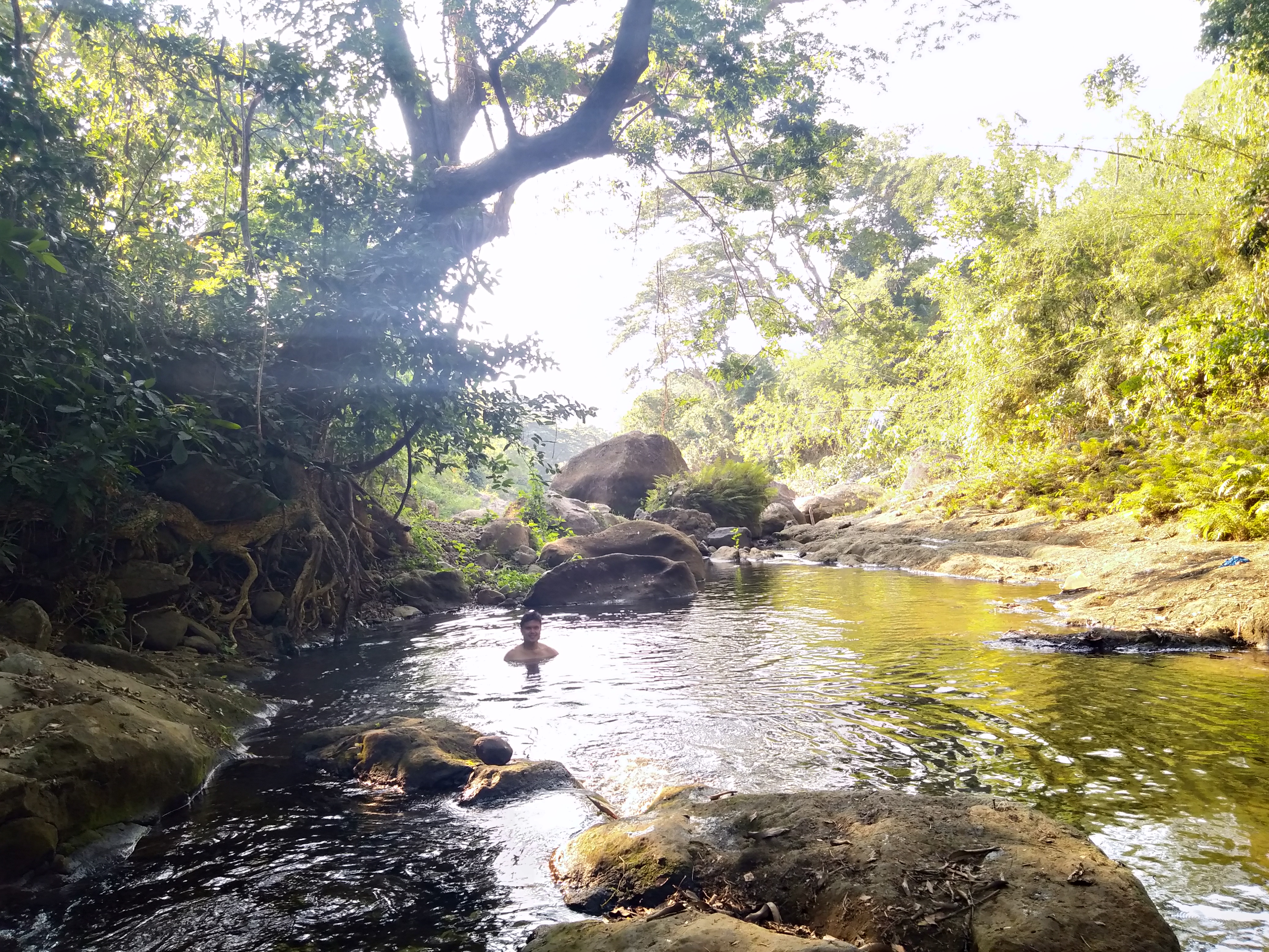
According to JM's mom, the big rocks in the river and the protruding roots along the river are completely submerged during the rainy season with the water level rising to as high as 5 meters more from the water level you see in the picture.

Helping to feed the chickens and dogs

After rinsing from a nearby underground spring,  Allan and I stayed to chat with the whole family.  We had a long conversation where they treated us with ripe banana for free. Earlier, we bought ripe banana from roving locals P40 of two bunches of bananas.

The DENR observation deck

Just at the back from their house, we climb on a steep trail heading to the DENR observation deck.  JM was with us to serve as our guide.  Literally, it was a series of cardiac assaults.

At the DENR Observation Deck (Model:  Allan R. De la Trinidad)

The observation deck serves as a watch tower to see if there are wild fires on the nearby mountains.  From this point, we can see Mount Tala, Mount Santunisan and Mount Palpag.   Mount Bulbok is not visible since it is covered by the heights of the three mountains mentioned.  I learned from JM that by scaling Mount Bulbok, you need to start your ascent through Mount Tala, then to Mount Santunisan and Mount Palpag and only at the third mountain that you will see Mount Bulbok.

Liong Mabilog Water Falls

This water falls is just a 10-minute walk from the jump-off camp site.  During rainy season, this is partially submerged.  By the time we arrived, this has been crowded with campers.  Allan and I strolled to this place at around 4:30 P..M. when all campers and picnickers left.

Wading from this point to the campsite

It was completely an excellent late afternoon walk and we looked for some parts where we can enjoy the scenery.  Allan and I along with JM were the only ones enjoying the sceneries.

This is just a random shot on our way back to the campsite

We had so much time then, but our concern was to look for an area where can capture a network signal.  There is no commercially supplied electricity in the area, but they generate electricity through solar panel that they use to light up the campsite at night.  The network signal was extremely erratic.  I noticed that I kept on receiving messages in my mobile phone but the moment I go online, it kept on loading only.

Our tour organizer provided us with a sumptuous dinner. We really had a great gastronomic experience.  Those who summitted reunited with us at the campsite and the campsite was adorned with colorful lights.  The problem was, the campsite itself was in a low lying area surrounded by mountain ranges and so there was no wind to cool us up.  It was so warm inside our tents that we cannot sleep.  We were sweating while lying down.  Good that at almost midnight, there was a downpour and it cooled us up and sleeping invaded our senses.

DAY 2

The start of the trek

The previous night during our socials, it was agreed that we start the trek at 5:00 A.M. so that it will not be too hot.  However, our organizers who were also our guides woke up late and there was not hosted breakfast meal served.   We were given coffee  to drink but I took my own Swiss Miss and bread.  I am not used not to eat rice for breakfast and so I felt weak then. We started our trek at 6:45 A.M.

Scaling Mount Tala (Model:  Allan R. De la Trinidad)

I was not feeling well at the start of the trek.  My stomach was desperately looking to be filled with rice and viand, but to no avail.  I was at the tail of the group.  I have no energy then to trek.

The passable road by quarrying vehicles

Initially, the trek started scaling Mount Tala.  We were strutting on a very wide road used by the quarry trucks.  Mount Tala is gradually losing its topographic identity as the continuous quarrying is eating up its height bringing to a lowered elevation.

Our group approaching Mount Tala's peak

If you will see, most part of Mount Tala  is quarried.  It is saddening that though quarrying is illegal, the local government of Cavite does not recognize or abide the law on anti-quarrying.

The denuded peak of Mount Tala

Based on the reading of our Altimeter app, the peak of Mount Tala was at 101 MASL or 331 feet above sea level.  Whether is it was accurate or not, I wouldn't care much less, because I knew that in just less a time, this elevation reading will even be significantly reduced due to continuous quarrying. The ascent to Mount Tala was just 25 minutes.  

The open trails after Mount Tala

According to JM's mother, after Mount Tala, we are going  to scale first Mount Santunisan and Mount Palpag.  But our guides have no idea about this.  For the 1 1/2 hours trekking, Mount Bulbok was not visible to us.

With our guide waiting for others for regrouping

The trails were consist of gradual assaults.  There were no big boulders and roots to step on.  It was simply walking.  We rarely had take five.

An uprooted tree along our trail (Model:  Allan R. De la Trinidad)

The sight of Mount Bulbok peak visible after 1 1/2 hours trekking

As far as I can remember, we had scaled two major and continuous assaults and I want to assume that these are the peaks of  Mount Santunisan and Mount Palpag.   However, I am not sure.

Trail leading to the summit was gradual

Noticeably, the trails are not that highly abused, because only a few mountaineers are on this mountain.  Some parts of thickly covered with grasses.

The campsite near the summit

The campsite has been erected with a DENR monitoring team house, but is already abandoned.   I suppose, the place is perfect for an overnight camping.  However, it can only accommodate few tents.

The DENR Project Marker at the campsite

From this elevation, Mount Marami and Mount Palay-Palay (Pico de Loro) are visible to the contour of the mountain ranges.

The water source near the camp site

There is no problem to camp at the DENR abandoned project monitoring house, since there a water source just a few steps away.  The water is safe for drinking and you can even take a bath if you like.

The shoulder campsite at a distance

From the shoulder campsite, it will take another 30 minutes to ascend to the summit.  And yes!!! the scenery this time is stunning.

On my way to the summit

Noticeably, the trail going to the summit is not really established.  Usually, those who climb here according the one guide (not our guide) I talked  to are simply satisfied to the abandoned DENR house.

Pursuing to scale the summit

The stunning view as captured from the summit

Finally, according to our Altimeter app, the elevation is measured to 645 MASL or 2,116 feet above sea level.  Mount Marami only measures an elevation of 405 MASL of its peak while Mount Palay Palay is at 664 MASL.

Of course, Allan my photographer was with me to the summit

I was just surprised that our two guides were not interested to lead us to the summit. They just told us to go ahead and they will follow, but they never did. I was disappointed that while Allan and I were pushing to the summit, the rest of them descended heading back to the DENR abandoned house.  It was only Allan and me who pursued the summitting.  The rest of the group did not bother also to scale the summit.  They were only halfway to it.

One of the trails as we backtrailed

After 20 minutes rest at the DENR campsite, we proceed with our descent.  This time, I was meticulously looking at the trail with appreciation.  I kept on capturing shots.

A far off tail-ender

I asked my guide to leave me at the tail end, because I kept on scrutinizing the beauty of the trail.  It annoys me when somebody at my back is waiting when I am capturing pictures.  Besides, I can not tell them, to make it fast so that they cannot be captured.  

My travel buddy, Allan occasionally stops and wait for me

Avoiding to be too close to the rest of the group

No! I was not ahead of him.  This is a scripted picture while we were at rest

Mind you, they were waiting for me.  They thought I am already in trouble.

I just love the sight of this tree along the trail

Fortunately, some parts of the trail are averagely forested and so we had cover from the heat of the sun.  At this point, we were already backtrailing for 1 hour and 35 minutes.

Back to the denuded trail of Mount Tala

It was too hot when we strutted on the open trails of Mount Tala.  That time, it was around 12:00 high noon. Imagine, having no breakfast for rice.  How can I have the energy to trek more?

It was really hot!!!

My "eat my dust" distance from my travel buddy

A long descent from Mount Tala

I still have water to drink but I preferred not to drink it since, it was as hot as the sun's temperature.  Thus, it cannot quench my thirst.

Still far from the jump-off point camp site

Descending Mount Tala gave no cover.  Thus, you have no reason to take five for a rest, but to walk despite having a heavy feet and heart.

My unmindful continuous steps had led me to arrived third to the campsite arriving at 12:35 noon at the place.  Our organizers gave us our brunch with boiled sweet potato, corn and banana as our snacks.  They were cooked while we were on the mountains. That was a great hosted brunch.  At around, 2:00 P.M. we have another meal, they  said it was for lunch.  Salad was served then. Great food!  Thankful to the good chef we had.  We left the place at 3:30 P.M. and arrived home at around 6:30 P.M.  I missed the Sunday Mass.


CONTACT PERSONS:

For this climb during the pandemic, it is easier to avail a tour package for this with the organizer,  Erwin Lazaro Doringo who can be contacted through his mobile number at 09128350516 or one of his tour coordinators  (the cream of the crop) Mark "Untong" Rodil with mobile number at 09952346727.


Wednesday, May 12, 2021

11 THINGS TO DO IN MINALUNGAO NATIONAL PARK

 Location:  Sitio Minalungao,  Brgy. Pias, General Tinio, Nueva Ecija, Philippines

The crystal clear emerald waters of Peňaranda River in Minalungao National Park

Minalungao National Park has given me something beyond my expectation.  Why? because it has been branded as good for swimming and its towering karts rock formation where families can enjoy the place with the kids, but being there personally I enjoyed many activities, and they are as follows:

1.  Endless photography and sightseeing


Every part of the park is worth a good photographic material.  No wonder because the place itself is a natural wonder.  Thus, it has been decreed as a national park.

My early morning experience after an overnight tent soundly sleep

As a background, this park is a protected area of the Philippines by virtue of the Republic Act No. 5100,  a legislation took effect in 1967.  It covers an area of 2,018 hectares with  its dominant features being identified with the charming beauty of  Peňaranda River outlined on both sides with 16-meter high limestone rock formations which nestles at the foothills of the Sierra Madre mountain range.

Capturing the empty "balsas" or bamboo rafts docked near the riverbank 

Our trip heading to this place started with a meet-up at the McDonalds outlet at the Centris near Quezon Avenue MRT Station where we left at 8:20 P.M. on a Saturday.  We were ten boarding on a comfortable Grandia and we headed to the province of Nueva Ecija.  We just had one stopover at a certain 7-Eleven Outlet in Gapan City to buy our necessities.  From there to Sitio Minalungao is still 34 kilometers driving thru the Minalungao Trail or 1 hour and 25 minutes to be exact.  We arrived there at 11:50 P.M. and our group just pitched our tents fronting the building where bathrooms and comfort rooms are housed.

The concrete tent zone at the foreground with the bathroom/CR building at the background

We had five hours soundly sleep inside our summer-type tents. After all, it was summer and we do not need the four-season tents.  My companions had boiled water for the coffee and Milo while I was roaming around the riverbank area as early as 5:00 A.M.  I took shower to freshen me up at around 6:00 A.M.  There were a lot of cyclists who joined us at the tent zone for some pictorials, hoping they had also savored an overnight camping at the place.

2.  Buy souvenir items and local products

Just one of the souvenir shops in the area just few steps opposite the concrete tent zone

Like any other tourist destination, the park is also equipped with souvenir shops and stalls.  Visitors are offered a variety of  local products, delicacies and souvenir t-shirts as well.  I just noticed, the locals are so nice and friendly.   Since, ours is a tour package, we had been booked for a guide in the name of Jonathan who was good in taking us pictures.

The main gate to the food court and the souvenir shops

After shower and break-camp, we headed to the food court for our breakfast together with our guide.  Indeed, it was such a refreshing morning breathing like a marathon runner in order to accumulate more fresh air which is not available in the metropolis.

3.  Feast on the food conveniently available in fairly good price

The pathway leading to the food court

The breakfast meal was charged to our personal account.  The food was okey.  It was like a fastfood chain.  You order and wait for about 5 to 10 minutes.  Therefore, if you intend to avoid crowd especially this pandemic where social distancing is a must, then go and eat here early.

The facade of the carenderia we had for our breakfast

Each order of food costs P75 (or US$1.57).   The choice of food are: Tapsilog (cured beef, fried rice with fried egg); Bangsilog (fried bangus, fried rice and fried  egg); Porksilog (fried pork, fried rice and friend egg); Hamsilog (Fried ham, fried rice and friend egg); Chickensilog (fried chicken, fried rice and fried egg); Hotsilog (fried hotdog, fried rice and fried egg).  You will wonder what  all these mean?  Let's have Tapsilog as an example.  Tap stands for tapa (tagalog term) for cured beef; si stands for sinigang in Tagalog which means fried rice; and log is from the word itlog in Tagalog which means egg in English. Now, if you are a foreigner, you can now decide which one you will order for your breakfast.  They also have fruits like mangoes and banana for sale.

Other choices of food meal package

If you decide to have a meal platter, you can have it for P150 (or US$3.14) ; a boodle fight good for 3 - 4 persons costs P800 (or US$16.72 ; and a Boodle fight meal package good for 6 - 8 persons costs P1,500 (or US$31.35).  What consist this meal package?  Fried tilapia, fried chicken, banana, salted egg, rice, chopsuey or it will depend on the request of the guests.

A comfort room facility inside the food court

Of course, if you feel that buying food in the park is expensive especially for families or groups who are in big numbers, then you can take with you your own food where there is no corkage fee.  You can also rent a charcoal grill for P50.

The spacious and scenic viewdeck

After breakfast, we moved to the viewdeck where from this point, we can see the inviting clear and tranquil pristine waters of Peňaranda River.  

The magical natural park (Photo credit: Kristine Joy Anne Capistrano )

In complete awe, our group had moved from the viewdeck, climbed to the massive rocks and endlessly fixed ourselves in backdrop where we can have the marvelous towering karts and the complete allure of Peňaranda River with its emerald clear waters tempting us to plunge on it with reckless abandon.

4.  Try a bit of bouldering

What is bouldering then?  It is a type of rock climbing that doesn't require a rope or harness, because you only climb up to 12-15 feet.  While rock climbing per se requires a rope and harness with an elevation of 30 feet off the ground.

An intimate union with the massive rock formation 
(Thanks to my photographer Sir Philleep Masaquel)

5.  Enjoy the most secured hanging bridge

The next activity we did was to cross on the most secured hanging bridge I've ever visited. It is in itself picturesque and according to our guide, this part is a favorite spot for a prenuptial pictorials.

The hanging bridge as captured from the view deck

The hanging bridge is just next to the view deck.  To avoid so much traffic, guests can take photos very early if they wanted to have solo pictures.

Thanks again to my photographer, Mr. Philleep Masaquel

I thanked the group for giving me the chance to be the first to have a pictorial in the hanging bridge of four different shots, but I have chosen the above photo for posting here.

The hanging bridge captured while we were on board our rafts  at 3:00 P.M.

A drone is the best photographic equipment to capture the place particularly the hanging bridge. It is quite difficult to take solo pics when guests are crossing it.  So, the best thing to do it is very early in the morning.

6. Soar like an eagle thru the zipline

Conquer your fear of heights at the zipline (Picture credit: Kristine Joy Anne Capistrano)

Yes, there is a zipline in  this park, but opted not to ride on it.  I am reminded of my Zipline experience at the Dahilayan Adventure Park of Bukidnon of its 840 meters, considered as the Asia's first longest dual zipline.

It is also a dual zipline (Photo credit: Kristine Joy Anne Capistrano)

The launch pad of the zipline is just near the tip of the hanging bridge.  It crosses the Peňaranda River.  I have no idea of its elevation and length, but I would presume it is just around 200 meters long.  

Calculating the elevation of the zipline

Boarding the zipline will cost you P100 (or US$2.09) one way.  Thus, a two-way would  be P200 (or US$4.18).  Not bad.  You will have the opportunity to capture the river in a wider angle including the rafts filled with the guests.

7.  Dare yourself for a challenging spelunking

Caving or spelunking was not a part of our itinerary but the park has a caves.  However, there is only cave open to the public.  It may not be as challenging as the Sumaguing Cave of Sagada, but it has own unique charm having magnificent stalactite and stalagmite formations within the cavern.  It does not charge an admission fee, but the park imposes a no-guide no spelunking policy.  If you want to try this, you should bring with you a flashlight since it is too dark inside.

One of the Minalungao's caves (Photo credit: Lakad Pilipinas)

8.  Scale the 1,000-concrete stair Banal na Krus (Holy Cross)

I was intrigued to read where it says 1,000-step climbing.  No! I don't think there are only 1,000 steps climbing the Holy Cross, because some of the stairs are long and flat where in that flat stair you will have 20 steps.  Yes, the trail from the jump-off to the summit are all concrete and they are not densely forested, so it is hot.

The concrete stairs trail

Even if it rains the trail has no mud

There are always benches to rest whenever you are tired

My companions are at rest after scaling almost 300 stairs

This stairs color coding is already in the higher elevation

We passed thru this resting shade

This covered walk will give you a hint that there are only more than 100 stairs left

And yes, the Holy Cross Marker on the summit is now visible

The summit - the final destination where the holy cross is erected

The holy cross is surrounded with a covered structure where guests rest

Our group stayed longer at this refreshing sanctuary and savor the cool mountain breeze.  From this point, you can see the picturesque lowlands. Blooming flowers decorate the summit beautifully.  The vendor selling cold drink was such a relief quenching our thirst away.

The Lost Tribe resting shade was more colorful during our descent

On our ascent, I never noticed the beauty of this resting shade.  It was our tour guide who suggested to have some pics inside.

All  the trails except for the covered one are open trails and exposed to searing sun

While having halo-halo refreshment near the jump-off point

Crossing back the hanging bridge

The rafts anchorage as captured from the zipline launching pad

9.  Bamboo Rafting

Preparing for our exciting bamboo rafting

Beyond bamboo rafting experience

Navigating to the river upstream

Families and groups on board the bamboo rafts

Enjoying a boodle fight while on board the bamboo raft

It was almost lunch time, and so we requested that our lunch be served in our raft on a boodle fight package.  Everybody was hungry then and I jumped off the raft just to capture the group while eating.

Feasting on the food were Kuya Tan-TanMadame Analiza Pineda and 
son, Dreiden Chase who were late for lunch.

After our lunch, I was busy looking for the best angle of the river. It was intensely hot then and I do not like to stay on water or at the raft.  I climbed on the shady part of the massive walls grown with endemic tree species.  The following are the pictures I captured.


10.  Swimming

Our group on a relaxing swim

Our group has a company of a 2-year old kid, Dreiden Chase, son of the couple  Analiza  and  Arhmond Pineda (partly hidden since he is carrying Dreiden). In green swimming jacket is Kristine Capistrano, our tour organizer.  I just wish then that my 1-year 3-month old son, Matthew was with us.

While the middle part of the river is deep, the rock-walled river banks are shallow.  It is safe to let yourself afloat since you are equipped with a swimming jacket included in the package.  There is a life guard who keeps an eye for violators who do not wear swimming jackets or announces the raft  which finished their rental time.  There is somewhat an under current which will carry you downstream even if you will not swim.  In most cases, it is better to just stay afloat than to go against the water current.

Enjoying a swim just near our raft

10.  Cliff diving

A local tour guide took this for me, not our hired guide

Look at those cliffs at my background, these are just some cliffs where guests can enjoy cliff diving.  These parts are deep and they are safe for diving.

Waiting for our time to be fully consumed

Time is up!!!! Last picture in the river.

Fees and charges at the park

  • Entrance Fee - P200
  • Parking Fee - P50
  • Bamboo raft - P500 (big); P250 (small)
  • Floating Cottage -  Ranging from P800 to P1,500
  • Spelunking entrance - P10

Note:  Comfort Room Fee has been added to the tour package, so that it's fee is not in a per entry basis.

How to go there

There are three options to visit this place.

1.  Thru Packaged tour

Nowadays, packaged tour is the best option for a worry-free tour.  Leave it to the legit tour  organizers.  Of course, I would recommend to you the best tour organizer  in the name of Miss Kristine Joy Anne Capistrano.  She can be contacted through her mobile number at 09064566847 or PM her to her Facebook account at Kristine Joy Ann Capistrano.

2.  Via Public transport  (Manila as point of Origin)

Board a bus bound for Gapan/Cabanatuan at ES Terminal (Cubao) which will take you 2 hours in a normal traffic condition.  Tell the driver to drop you at Puregold Gapan.  From there, charter a tricycle heading to Minalungao National Park for approximately 1.25 hours.  The rate depends on how you haggle with the driver.   This pandemic time, the roundtrip is P500 for two pax as the maximum passenger capacity, though this is not a standard rate.   Since there is no network signal at the park, you need to give the specific time where you will be fetched from the park in going back to Gapan city proper.

3.  Via Private vehicle

Take the NLEX route and turn to Sta. Rita Exit.  From there, proceed right and go along the Candaba - San Miguel Road.  Continue driving till you approach Bucana of Gapan.  Don't hesitate to ask locals for the right direction to the park for there are several roads going to this destination.  The best time to travel is late in the evening where it will only take 3-4 hours.  Just take note that there is heavy traffic during rush hours and it will you 5-6 hours on a long queue of vehicles mostly delivery trucks coming from the north.