Location: Rodriguez, Rizal, Philippines
Major jumpoff: Brgy. Wawa, Rodriguez, Rizal
LLA: 14°44′25.3′′ N, 121°11′30.4′ 517 MASL (+460m)
Days required / Hours to summit: 1 day / 2-3.5 hours
Specs: Minor, Difficulty 4/9, Trail class 1-4 with limestone scrambling
Features: Limestone formations, scenic views of Sierra Madre and Rizal province
(Source: Pinoy Mountaineer)

Hapunang Banoi is just one of the three mountains in Rodriguez, Rizal which I climbed where all of them are notably with limestone formations. The other two where I climbed earlier were Mount Binacayan and Pamitinan. I climbed the latter for twice. According to the locals, its name Banoi is a Tagalog word for eagle, where its name was derived which means a folkloric seat as the ‘place where eagles come to dine’.

Banoi and Pamitinan share the same jump-off point and the same trail till it reaches to the Junction (three food stores of bamboo and nipa structures are there). From that point, Banoi has a trail which turns to the left while Pamitinan is heading to the right direction.

After crossing the hanging bridge, the trail cuts through a few houses where assaults are continuous. The trail is grown with verdant vegetation. When it's raining, the trail on this part is muddy. Newbies here keep on taking rests to catch on their breath.

The ascending trail continues till it reaches the massive rock wall where very inviting long bamboo seats await the climbers and cold drinks and buco are being sold by the enterprising locals.

For a regular climber, it takes less than an hour from the hanging bridge to the junction. Some parts of the trail requires a big leap as you have to step on big roots or big mounds of rocks.

From the junction, culminates a trail which is dry and with bamboo groves. Sharp limestone rocks are becoming evident. Some points are open showcasing the breathtaking scenery of the low-lying areas which serve as viewdecks.

Since the trail has sharp rocks, trekking becomes slow. Besides the trail is so narrow and at the edge of a cliff but it offers a panoramic view. Climbers are left in awe that they can not resist the temptation taking shots and selfies.

You need to hop from one big rock to another. At this point one is really exposed to the scorching heat of the sun. So, it is advisable the ascent should be as early as 5AM in the morning since there will be no cover from the junction to the summit.

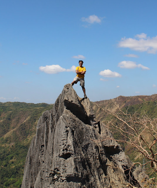
The picture above is not a part of the usual trail. I just climbed there to get a daring shot. At its back is a rocky cliff. Not all climb this point. It might be risky for those who are not daring enough to conquer heights and defy gravity.

In the picture above, I was still on the same spot but the photographer has transferred to higher elevation by climbing a tree. If I were the photographer, I will not take this shot. It does not define height, anyway. This shot was in the same spot in my cover picture of this post.

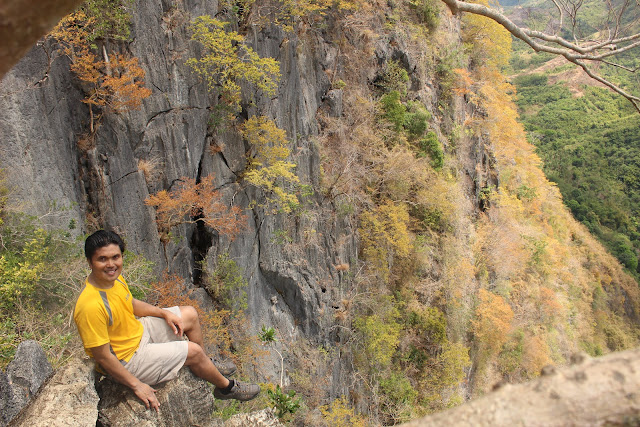
The picture was a 20-minute trek from the last photo where I had a daring shot. Below it are really deep ravines and cliff measuring around 150 feet. The backdrop here is just amazingly stunning. The bright yellow trees adds a different glow. In this photo, it does not define a death-defying cliff edge, but in reality, one false move here is more than death-welcoming.

By the looks of it, the photo above looks so cool but only brave hearts do this. Not all wants to provoke death and accept challenge. Anyway, all of us were happy that our guides were giving us then tips on how to be safe in every move we did. They were even the ones taking our pictures.

Scaling to this point was really risky, the rocks were so unwelcoming. You can not just avoid rashes and skin cuts. I mean, there was no room here for skin bruises but just skin cuts. One has to be cautious enough to grip and hold on to rocks. Some of them may not even be stable. Their sharpness looks fierce but fragile when you hold a grip over them.

Being at this point was really monumental. I can't explain my feelings. It was like, I was on top of everything and I own a vast of kingdom. I was like claiming my dominion over nature.

What I like in this mountain was its generosity to give best scenery. Wherever you aim your camera, it will result to amazing captured photos. I really love this climb!!! Why not try it by yourselves.

I have not wasted my time to document every beautiful angle I saw. As we were approaching the summit, rocks were becoming fiercely sharp. I noted that two of my male companions who were wearing sandals were not able to pursue the climb as their sandals were disengaged. The rocks were quite punitive.

While the summit has fierce rock edges, its view was stunningly beautiful. As long as you are cautious with your moves, you will be in good hands. You will have less skin cuts. I did have two. Anyway, the guides are so mindful of their climbers. They are watchful and they would even give the advance before you do the wrong move.

Our group stayed for more than 30 minutes at the summit. Good that there were no other groups next to us. The summit is not wide enough to accommodate climbers. You know, I really like the backdrop of the summit.

Our guide demonstrated to me on how to have a shot like him, but I decided not to because, it was so risky. I saw no support if ever I mishandled my footwork. It was then I realized, I have my limit.

It was already hot and so we took cover below the summit where there was a fissure. Surprisingly, it was cold inside it. But the problem was, we have to brave up the sharp edges of rocks going down which considerably deep below. And after resting there, we need to climb again to be on our trail for descent.

After descending from Mount Hapunang Banoi, we decided to freshen up for a bath in the cascading Wawa Dam. This can be the best side trip when climbing the mountains of Banoi, Binacayan and Pamitinan.


Not only that, along our way to Wawa Dam, you can vegetables and fruits at a cheaper price. If you are hungry, carenderia are many particularly when you are heading back to the DENR Office. Need to go back to Cubao? There are tricycles available going to Luvers in Montalban and then take a jeep or van going back to Cubao.
My expenses for this climb is summarized as follows:
| SN | Particulars | Amount |
| 1. | Round Trip Van Fare from Farmer’s Cubao to Louver’s Montalban and vice versa | |
| 2. | Share in Round Trip Tricycle fare from Louver’s to DENR Registration Site (P15 one-way) | |
| 3. | Share in guide for a maximum of 8 for a fee of P500 | |
| 4. | DENR Registration Fee | |
| 5. | Donation to Barangay (Optional) | |
| 6. | Lunch in one of the Carenderias in the jump-off point | 7. | Breakfast in one of the Carenderias in the jump-off point |