General Location: Quezon Province, Philippines
 The hostile topography of Baliscar Islet
This is a hosted trip of my friend,
Thelma Bautista in their ancestral home in Sabang, Barangay Mainit Sur in the municipality of Perez. Perez is a part of the Alabat Island consisting of three municipalities, namely: Perez, Quezon and Alabat. This island is a part of the Quezon province of the CALABARZON Region. Our third companion to complete the group is another friend,
Teresa Santiago Corpuz
ALABAT ISLAND, QUEZON PROVINCE, PHILIPPINES
Location: Sabang, Barangay Mainit Sur, Municipality of Perez, Alabat Island, Quezon Province, Philippines
 Vicinity Map of Alabat Island (Google Map)
 Upon arrival in the low tide Barangay Mainit Sur: Our host destination
Trip started with a bus from Cubao to Atimonan, Quezon province. From Atimonan port, our host who brought with them their own motor boat picked us up. While waiting, we were on its fish port and were haggling to buy fish.
 Our host house's extension refreshing hut
Our host allowed us to stay in a refreshing hut while they were serving us with unlimited buco fruit in preparation for lunch where the dish were all seafoods, salmon and steak tuna.
 An improvised wooden bridge
From the window of our host's house, I can see a wooden bridge where I have seen some locals crossed on it. Though, without it, they can cross on a creek during low tide which empties to the sea.
 Single motor cycle crossed the wooden bridge
I was wrong to assume that the wooden bridge was really constructed for the locals to cross but for their only means of transportation, the single motor cycle or the habal-habal as called in some parts of the country.
 River cruise through bamboo raft
After having our lunch, our group consisting of Thelma Bautista and Teresa Corpuz, decided to have a river cruise in a nearby river. This river empties to the sea just near our host's house.
 Upstream river cruise
From the mouth of the river which starts from the sea, we headed upstream where it took us for an hour just for one way and another one hour coming back. On our way, we happened to meet locals who are harvesting their "bubo" or traps for crabs or alimango in local term.
 A local kid on an improvised mangrove branch diving board
While approaching the mouth of the river, we have seen some kids enjoying diving in some parts of the mangrove branches. I remember when I was still a kid where I have been doing it with some friends and my elder brother, Michael in our province.
 Tempted to dive from the mangrove branch
Witnessing the simple joys of these local kids, I was also tempted to join them in their diving spree. However, when I crawled to one of the mangrove's branches, they gave way for me.
 The swampy coastline
Late in the afternoon, I went around the place alone to enjoy the ruralscape which I have been missing so much. I had the chance to meet some locals and have a conversation with them asking them about the island's history and way of living.
 Accidentally met a mountaineering friend in the name of (left) Gio Paolo Espital working with an NGO in the island
It was surprising that when I was strolling along the beach one nice morning, somebody approached me and greeted me with my name. He was with a colleague who is also working with an NGO operating in the island.
 The island's mangrove forest reserve
The people living near the beach coast rely there income from fishing. Yes, it is a fishing village. There are a few sari-sari stores I have seen and the island has its own supply of electricity.
 Boat carpentry business is also in the island
Aside from fishing, boat building is also a means of living in the island. Those who are living from the landlocked part of the island are enjoying farming and copra production.
 Narrow road connecting to other municipalities
The part of the island where we were hosted is not the center of activities for it is just a small barangay but the island having 192 square kilometers land area is consist of three municipalities which I mentioned in first paragraph narrative has also schools which I did not visit due to the absence of transportation.
BALISCAR ISLAND>
Location: Brgy. Villa Mansano Sur, Perez, Quezon Province, Philippines
 Vicinity Map of Baliscar Islet (Wikimapia)
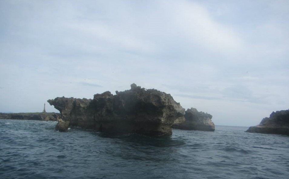
 The islet as captured from a distance
Baliscar Islet is a one-hectare uninhabited islet in between the islands of Cagbalete and Alabat. The land is made entirely of jagged rocks, with a lighthouse standing at the west. At the south, travelers can visit a cave during low tide and seek refuge from the sun.
 Baliscar Islet as captured from its southernmost edge
Our boatman from Alabat told us that we will have an island hopping which includes Cagbalete where I have visited already. When he mentioned about Baliscar Islet, I raised my eyebrows because it seemed not familiar to me. However, when he said, we are going there for its lighthouse, I became excited.
< br>
 Getting closer to the islet
The boat ride from Alabat island was more than an hour to reach the islet. There were rough waves around the island and we docked 10 meters away from the sharp rocky shores of the island. I asked our boatman if we can dock in an improvised port of entry but he said there was none.
 Navigating towards the point the boat will dock closer to the shoreline
When I jump off from our boat, it remained afloat and nobody from the boat was willing to down. We are a company of 6 including 2 boatmen. But since I really wanted to go down one boatman accompanied me to the islet. I braved to swim across the dark blue waters towards the shore where strong waves lashed out the rocky shores. But before that, the boatman dived along with him a rope to anchor the boat to a rocky cliff. Then I dived to the water with so much fear in my heart but yelling to the boat to keep close to me because I really can’t see the seabed. I was even cautious because if the waves will catch me, my body will be smashed towards the sharp rocks. Finally, I reached the island but I crawled because the rocks where I am supposed to stand were very slippery.
 Our boat afloat 10 meters away from the rocky shoreline
Trekking on the island was not easy because there was no flat surface where I can stand with stability but sharp rocks. Good that I brought with me my trekking sandals. I was so cautious of holes in between the rocks because I have seen eggs of the sea snakes. The islet was obviously inhabited with birds called “Balinsasayaw” and sea snakes. So, to conquer the island is really a big challenge.
 The boatman who served as my guide was ahead of me a few meters
I was so cautious of my every step not just because some rocks are very thin and sharp in very close interval, so I have really to watch out for my step but also snakes are breeding in some holes of the hostile trail.
 The entry giving the sight of the lighthouse
Climbing up on sharp rocks takes a few meters high and it was really a struggle. This time, I told my guide not be distant from me. Even with my trekking sandals on, I still feel the sharp edge of the rocks.
 Just rested from a challenging rocky climb
From where I rested, I did not even want to sit because the rocks were like piercing my behind. But I need to stop to recharge myself in battling farther a longer and challenging trail.
 The lighthouse at a distance
Though I have seen the lighthouse at a distance, I was still wary because not only the trails are disturbing but the sound of flying birds are very annoying where they fly above you in bigger number. I was like in a place where once the dinosaurs had existed.
 With very slow steps the lighthouse waa still too far
Along the trail, I saw a sea snake circling an egg fighting with the balinsasayaw bird. I just don't know where the egg belongs, but I kept distance from that animals' clash.
 The islet's edge overlooking from afar the Alabat Island
Despite the hostile topography, I still managed to stay for 30 minutes at the foot of the lighhouse. Then, I walked near towards the end of the island just to check what I can see there.
 The birds as seen when I already boarded the boat
Going back to where the boat was docked was another struggle which took me 45 minutes. I needed to swim back to the boat. This time the waves were stronger and even smashing not only to my face but to the rocks around. When carried by the waves I tend to get closer to the islet's shoreline. Thus, I was given a rope to hold on going back to the boat. The deep waters where I swam was even darker blue. I was scared that a shark might be pursuing me from beneath. Hah! I maneuvered to swim as fast as I could but the waves keep pushing me ashore. So, I told my guide to push me towards the boat.
 One more glance of the islet
It was a great relief to me when I was already on the boat and we were heading to Cagbalete Island. However, I wanted to go back to Baliscar someday with a company of brave souls.
CAGBALETE ISLAND
Location: Lamon Bay, Municipality of Mauban, Quezon Province, Philippines
 Approaching Cagbalete Island
This was the second time I visited the island. Thus, for a longer blog post which I had in my first visit, just read this
link for a more comprehensive and informative post.
 Early lunch while on board for a 30-minute travel to Cagbalete
It was already 10:30 A.M. when we left Baliscar, so we arrived in Cagbalete at around 11:00 P.M. Thus, while on board, we had an early lunch.
 Spent our time mostly at Villa Noe Resort
Normally, by this time, it is low tide in the island and our boat was docked far from the shore line. We had rested a lot at Villa Noe and we did not move far from this point.
 Relaxing on a not-so-hot late afternoon
The shady part of where we stayed gave us comfort to have a nap in the afternoon, though occasionally we walked along the shore to collect some shells.
 Thelma Bautista in her brisk walking mode as she termed it like that
We stayed in the island till 6:00 P.M. until such time that high tide was invading the shores and just good enough so that our boat can pick us up for a sea travel going back to Alabat Island.
MAUBAN TOWN DAY TOUR
Location: Municipality of Mauban, Quezon Province, Philippines
 The busy commercial district of Mauban town
Our last day was spent for a day tour in Mauban town which was 1 1/2 hours boat travel from Perez of Alabat Island. This was not my first time in Mauban since the jump off point of my first Cagbalete trip was also in Mauban.
 Approaching Mauban's wharf
Mauban's port maybe one of the busiest not only for cargo ship vessels but for passenger boats coming from different islands hearby. Thus, it can be seen as a center of trade and commerce.
 Passenger boats and fishermen's boats are docked near the town's wharf
Muaban, though a laid back town is a first class municipality of the province of Quezon. It has a total land area of 55,160 hectares subdivided into 40 barangays. Mauban's industry is primarily based on agriculture. though its trade and commerce ranks second.
 The town's coastal board walk
It is of no surprise that Mauban is already invaded with establishments branching out from the metropolis of Manila. This is a town where some of the islanders buy their food supplies and it makes its trade and commerce vibrant.
 Furniture and fixtures are being sold
Aside from farm and crop produce, the town also boasts the availability of shops for furniture and fixtures.
 Handicrafts and herbal/medicinal plants are also being traded
It is interesting to note that handicrafts and herbal plants are being sold equipped with literature and brochures on their usability and curability.
 The Rizal Hill Park
With an elevation of 27.5 meters above sea level, Rizal Hill Park has a 360-degree panoramic view of Lamon Bay, Pacific Ocean, Mauban town, and Sierra Madre mountain range. It is located in Barangay Rizaliana and free of entrance.
 The municipal hall of Mauban
I failed to visit another town's park in the name of Gat-Uban Park and Mauban Museum, since I got occupied of looking for their delicacies for pasalubong.
 Mauban Gymnasium
We were still busy then shopping for more pasalubong when Thelma's relatives which served as our host in Mauban invited us for a sumptuous lunch.
 Teresa Corpuz and Thelma Bautista with the latter's newphew
Our host's house was in a festive mode as the whole clan was there to welcome Thelma for she has not been visiting them for quite some time. Teresa and I were just observers, but we had eaten so much of their food.
 Our last stop was at St. Bonaventure Parish Church of Mauban
It was already early in the evening that we left Mauban boarding a bus for Manila. Mauban is 152 kilometers from Manila for 4 hours bus travel via Southern Luzon Expressway/Pan-Philippine Highway/AH26/R-3.
HOW TO GO THERE
Going to Atimonan:
Take a JAC Liner (Buendia Terminal) bus with a signboard of SM Lucena for 4 hours Then, from there, board a van going to Atimonan for an hour.
Going to Alabat Island and Perez Municipality:
By Public transport: Take a roro to Alabat Island, then a habal-habal going to the municipality of Perez.
By Chartered transport: Take a chartered boat from Atimonan Port directly to Perez municipality.
Going to Baliscar and Cagbalete Islands:
Take a chartered boat to these destinations
Going to Mauban:
Board a passenger boat from Perez to Mauban
Going to back to Manila
Take a bus going to Manila from the town's bus terminal.