Location: Nueva Vizcaya and Benguet
Jump-off points: Kayapa, N. Vizcaya; Brgy. Tinongdan, Itogon, Benguet
LLA: 16.31916°N, 120.80166°E, 2150 MASL (7,054 feet)
Days required / hours to summit: 2-3 days, 9-10 hrs
Specs: Major climb, Difficulty 5/9, Trail Class 1-3
Distinctive features: Pine forests, highland villages, views of Cordillera peaks
 After registration in Kayapa of Nueva Vizcaya
This is my third climb in Mount Ugo as a joiner of the group organized by Mr. Timothy Mislos, my climbing buddy in my Mount Kanlaon climb. We came from different organizations and in the chat group we organized our chat group meeting, majority agreed that this will be a day climb instead of a major climb which should be done overnight. Most joiners are very young and three of them were just beginners
Who would dare to make Mount Ugo a day climb most particularly the beginners, when it has long trails to trek on combined with flat ones and numerous cardiac assaults most particularly when starting to ascend from Kayapa. After all, the mountain is the highest peak in a chain of mountain ranges with an elevation of 2,150 meters above sea level or 7,052 feet. Its name was derived from the Ibaloi word “Ugoan” which means “to cut the neck of throat”. It was discovered as one of the most favorite mountains to scale by the mountaineers when there was a tragic PAL plane crash in 1987 just few meters below its peak. Some professional mountaineers then volunteered to accompany the bereaved families of the plane crash victims with the assistance of the local guides in visiting the site for memorial activities. As such, its cool climate, unique scenery and flora had enticed some other mountaineers to experience scaling the mountain.
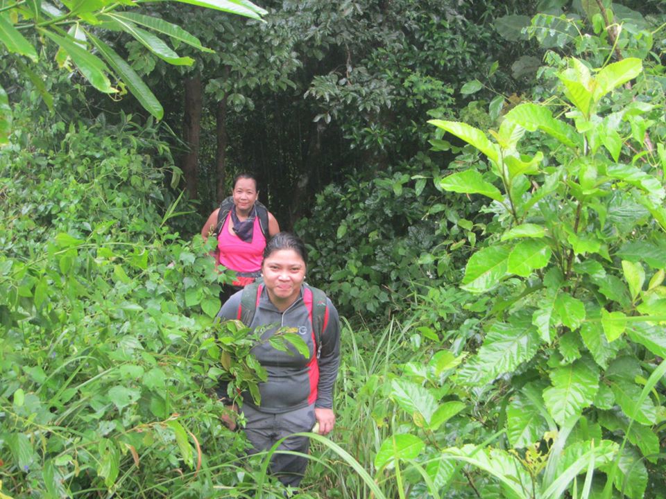
 The the first wave of cardiac assaults with a jungle forest trail
We left Manila at 11:00 P.M. boarding a Victory Liner and in Aritao at around 4:00 A.M. of the following day and we waited for our chartered jeepney to Kayapa for another one hour drive. Kayapa town where we had our registration from its barangay hall had a market where we can buy food supplies. Since the group intended to have a day climb, cooking stoves and tents were not a part of our load. I knew we can't make it a day climb but I also did not bother to bring those stuff with me.
 Just one of the rests on the first wave of cardiac assaults
Funny, that my climbing buddies even bought meals from Jollibee and McDonalds for takeout. While I did not because I knew I can buy food from Kayapa market. I only took with me food containers.
 Prolonged rest due to cardiac assaults
 The dense pine forest serves as a shade from the heat of the sun
We started the trek from the jump-off point passing through houses and the trail were concrete stairs with metal railings. Though it was ascending. It was only early in the morning but it was already hot.
 viewdecks of neighboring mountains were everywhere
The endless cardiac assaults had led us to Indupit Village with a few houses at almost 12 noon. We decided to stay in an wall-less abandoned house for our lunch. Others just went out and lied on the grassy ground. After all, it was cold already because we were already in a very high elevation.
 Our group had different pacing
The flat trails in a form of rough road passable by a vehicle were quite long and winding roads. The seating heat of the sun was on while we endless trek. However, we were amazed by the scenery that we see. Every sight around us was just breathtaking.
 Regrouping after long plain walks
Since there were three beginners and were not ready for long trek, they are somewhat left far behind. Thus, our expedition leader (EL) in the name of Timothy told the lead pack and others to stop so that we can regroup as one whole group.
 The reliable lead pack
I was a part of the lead pack. More or less, I knew what exactly how to climb Mount Ugo as this was already my third time. Still a few others are left far behind.
 After long, flat and winding rough roads
We happened to pass thru a water source and they loaded their water containers with cold water. My big backpack was loaded with 6 liters of Absolute Distilled Water. Thus, I did not bother to get cold water from the water source.
 The white mark at the background is the trail we trekked
It was already 4:00 P.M. and we were still struggling to head for the summit. Our three local guides were reminding us that they can only accompany us to the summit because they have been paid for a day climb.
 Looking ahead and figuring how far still left for us to trek
 Moving on with speed since I was chasing the guide on the lead
I was quite worried then how we will manage to make it to Tinongdan on time because we even haven't reached the summit and descending from there is still a long way to go.
 Noticed something on the trail
I had just noticed that the trail as compared with my first two climbs here were not as pine forested as it was before. As far as I can recall, the trail heading to the summit are somewhat grown with more pine trees.
 The black colored trail was an evidence that trees and bushes were really burned
 Starting to ascend to the summit
Regrouped at Domolpos village for loading cold water from its water source. Had an ample time to rest to regain energy from such a long trek. This is in preparation for ascending to the summit.
 The remnants of burned trees
 Where are the pine trees?
 So disappointing to see the burned trees
 The ascent to the summit
 Arriving at the summit ahead of the group with the lead guide
It was a consolation that the summit was still crowned with pine trees giving a better view than at the shoulder of the mountain which was burned already for farming purposes.
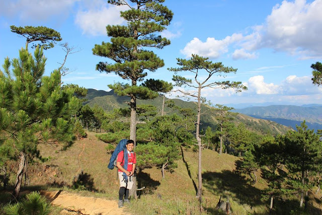 A part of the picturesque summit
I was lucky that our guide knew how to get good angle shots with proper instruction. While waiting for the rest of the group, I had already enjoyed a lot of pictures
 Another rewarding view captured at the summit
It took more than a hour for the whole group to be formed at the summit. It was already 5:30 A.M. The air was getting colder and the fog is slowly invading the summit. While waiting, some of us were having snacks. With the magnificent at sight, picture taking was really inevitable.
 Still a picture taken at the summit
When our group was already complete, we had a quick group photo and our guide bade farewell to us. They are going to go back to Mayapa. Anyway, four of us in the group knew the trail down to Tinongdan.
 Rushing for descent
It was around 5:45 P.M. when we started to trek down from the summit. Our young blood climbing buddies were running down the trail. Though, there were some trail which were steep.
 Gradually darkness is spreading
We took our head lamps because it was getting darker. The trail if passed on a day light is really beautiful as it is surrounded by pine trees. The trail was becoming steep and not navigable due to dry twigs that blocked it.
 While at Tinongdan barangay hall the following day
Obviously, ours became a night trek. We continued trekking till 11:00 P.M. Because the two beginners can no longer walk, our group stopped on a trail with cemented structure which the irrigation passes thru. From there, we all lied down so tired while a few was on the rough ground and still few on the grass. Besides, we did not have a tent to use and we have nothing to cook. Because of this, we knocked at two houses in Lusod Village which happened to be a store and begged to buy food from them. Fortunately, they have cooked rice and we bought their canned goods for our viand. We have eaten our dinner.
 Having breakfast at KFC Session Road in Baguio City
We resumed our trek at dawn and reached Kawayan village and crossed its footbridge bridge at 3:30 A.M. As we crossed it, we further walked a few meters and rested on the cold cemented road of Kilometer 0. Nearby were two houses where I opted to lie down in one of the tables outside the house. We waited there for our service vehicle going to Tinongdan Barangay Hall. It was already 7:00 A.M. when our vehicle arrived. We had a drive then to the barangay hall and from there we took our bath. Dried a bit our wet clothes. There were a few stores around to buy our necessities including food. Then, we headed for Baguio City
 Buying some pasalubong at Baguio Central Market
While in Baguio City, we had our breakfast at KFC along Session Road. Then, we had a walk to Baguio Central Market to buy some pasalubong, vegetables and souvenir items. Then, we headed back to Manila.
SAMPLE OVERNIGHT ITINERARY
I am providing here an ideal itinerary we used in my first and second climb in Mount Ugo.
Day 0
21:00 Assembly at Victory Liner Kamias, Q.C.
22:00 ETD from Victory Liner Kamias going to Victory Liner Stopover, Aritao, Nueva Vizcaya
Day 1
04:00 ETA at Victory Liner, Aritao, Nueva Vizcaya
04:30 ETD from Aritao going to Kayapa via chartered jeepney
06:00 ETA Kayapa. Registration at PNP Station. Marketing of additional food stuff and breakfast
08:00 Reorientation. Giving some reminders and instruction. Observe buddy system
08:30 Start trek
11:00 Indupit Village for lunch. Load water from water source
12:00 Resume trek
15:00 Quick stop at Domolpos Village. Last water source
15:15 Resume trek
16:30 Campsite. Set-up Camp. Cook dinner
17:30 Dinner
19:00 Socials
22:00 Rest Overnight (RON)
Day 2
05:00 Wake up call
06:00 Sunrise viewing. Breakfast
07:00 Break Camp.Start trek to summit
07:30 ETA at the Summit
08:00 Begin descent
11:00 Lusod Village for lunch
12:00 Resume trek
15:30 ETA Kawayan Village. Then continue trek to hanging bridge
16:30 Arrival at the waiting shed KM 00
18:00 Tinongdan Brgy Hall. Clean up.
18:30 Dry up a bit wet gears/clothes to make it lighter in weight
19:15 ETD from Tinongdan Brgy Hall going to Baguio via chartered jeep.
20:30 ETA Victory Liner Terminal. Baguio. Buy some pasalubong/other stuff. Dinner
22:00 Home Bound