Tuesday, May 5, 2020

MASUNGI GEORESERVE

Location: Kilometer 47 Marcos Highway, Baras, Rizal, Philippines


Challenging yet safe outdoor activities at Masungi Georeserve

Prior from its conversion as a conservation area,  Masungi Georeserve was a 2,700 vulnerable land.  The name Masungi is derived  from the word "masungki" which translates to "spiked" as evidenced by its abundance of limestone landscape.  Is located on the upland part of Baras in the province of Rizal where its initiative of environment protection is being led and funded by Blue Star Construction & Development Corporation and the foundation body of Masungi Georeserve along with the communities of Pinugay, Baras, Cuyambay, and Tandang Kutyo.

Early breakfast on a stopover along the way since we left Manila as early as 5:30 A.M.

Visiting this sanctuary requires an online registration and payment thru the bank where the reservation should have a maximum number of 13 in a grouip with a day tour fee of P1,800.  Guests should expect that visiting this place is absolutely communing with nature where food is not allowed, though included in the package is a provision of light snacks and refreshment before exiting the trail.

This is  how the main entrance looks as seen along the highway

The place itself has been developed for over twenty years already to protect the rich biodiversity of the area where more than 400 species of flora and fauna have been documented as  the  area of their habitat, not to mention that the limestone formations have already aged for around  60 million years and they have to be protected from illegal loggers, quarries and other man-made activities whose intention is to put the area into complete destruction and  degradation.

The non-concrete road leading to the  georeserve park for a 5-minute walk

Since there are no public vehicles plying to this area, guests who wanted to visit the place should avail of private vehicles.   In fact, our group had chartered a van charged to us just to reach the place.   At normal traffic condition, it can be reached at 3 to 3.5 hours  from Manila International Airport (Ninoy Aquino International Airport) or 1 to 1.25 hours from Quezon City.

The park's location map

Guests are advised to take a heavy breakfast meal since food is not allowed inside and there are no stores selling anything.  This is being done to ensure that no garbage will be left by the guests as they tour or navigate the park.  Though before exiting, a light snack is being served to include a sandwich and juice out of the organic farm produce of the locals.

The second entrance leading to the natural enclave of the park

You will be enthralled as you gaze on the limestone rock formations right from the second entrance abundantly grown with deep rich green flora species. Concrete stairs will guide you where to go.

Obviously landscaping development has been injected to make it eco-friendly

The park offers packages for activities like: discovery trail, discovery trail at night,  legacy trail, dining, company events, group educational tours for schools and weddings.

Look and behold how the place entices our human eyes

The tour package which we availed was the Discovery Trail wherein the trek duration was almost four hours including the orientation, immersing ourselves with the karst terrain of the park.  Our group was in a total of 13 as it is the maximum limit of a group.  There is no crowding of guests because booking is definitely controlled.  With just a few number, every guest will have his/her moment of pictorials.

We were in Silungan where it serves as the receiving and briefing area of guests

It was in Silungan where we had undergone our briefing on the do's and don'ts while inside the sanctuary.  It is in this place that we refilled our drinking water for free as food is not really allowed inside.

Silungan as vacated by us after the briefing

After the briefing, we have been given ample time for clean-up and answering the call of nature. Forest rangers had been assigned to us.

The urinal and washing facility inside the comfort room

Seems cool! very clean and eco-friendly

The washing facility on its almost natural form

Fully mesmerized of this naturally enchanting place, we were given time to roam around and completely commune with the charming fauna everywhere and the following pictures are just the proof.


After personal preparations, we started our trek as led by our very accommodating forest rangers whom I believe to be locals.  Well, they can communicate well and explained to us every part we pass thru.

Some trails are simply friendly and manageable

and our trek started . . .

then passing through this part . . .

And yes, I preferred to be at the tail so that I capture the trail without photo bombers

another type of trail . . .

Ascending through stone-carved trail

The trail with a rope portion for safety

A flat concrete surface very inviting for rest

And yes! I succumbed to rest for awhile

What is this for, by the way?

Of course, to wash our shoes for possible accumulation of clay and dirt

Because we need to go up through net trail with clean shoes

And there I go! I was at the tail and seemed like a sweeper

Passing through a narrow rock opening squeezing in my willing body

My climbing buddies

That's Lito Perenon, our trip organizer and my fellow PNB Mountaineering Club member

Going up again in trail-roped portion

Just about to ascend to the next destination

This is "Sapot" - a web-style viewing platform where the spectacular view of Laguna de Bay can be captured - the biggest lake in the Philippines

A group picture at the Sapot viewing platform

The 60 million year old limestones where the Sapot is anchored

And this is how it looks underneath, I went down there

Part of the Sapot limestone support

Other climbing buddies Sir Jun Odonzo and Mam Arleen Bactin strutting this literally hanging  and swaying bridge after the Sapot viewing platform

Still part of the swaying hanging wooden trail

Back to the rocky trail

Descending the rocky trail

and a touchdown to this friendly trail

with a few steps away awaits this comforting hammock

then proceed to a flat concrete trail

Another body squeezing into a narrow rock opening

A gradual descent with concrete trail

White the group is at rest. A swing for four, isn't it exciting?

Moderate ascent led by Dr. Gennie Tagab - my fellow PNB Mountaineering Club member

A take five moment in between shady limestone formation

The take five extended as we regrouped

Another gradual ascent

Another gradual ascent in the a friendlier trail

Sir Jun and Mam Arleen, my Bff on a pensive mode on whether to have a take 5 or proceed

This one opens to a more exciting attraction

Enters at this point

Passing through this point

Stay here for another short briefing

Out into the Ditse and Patak - an air house

With the Patak Air house at the background

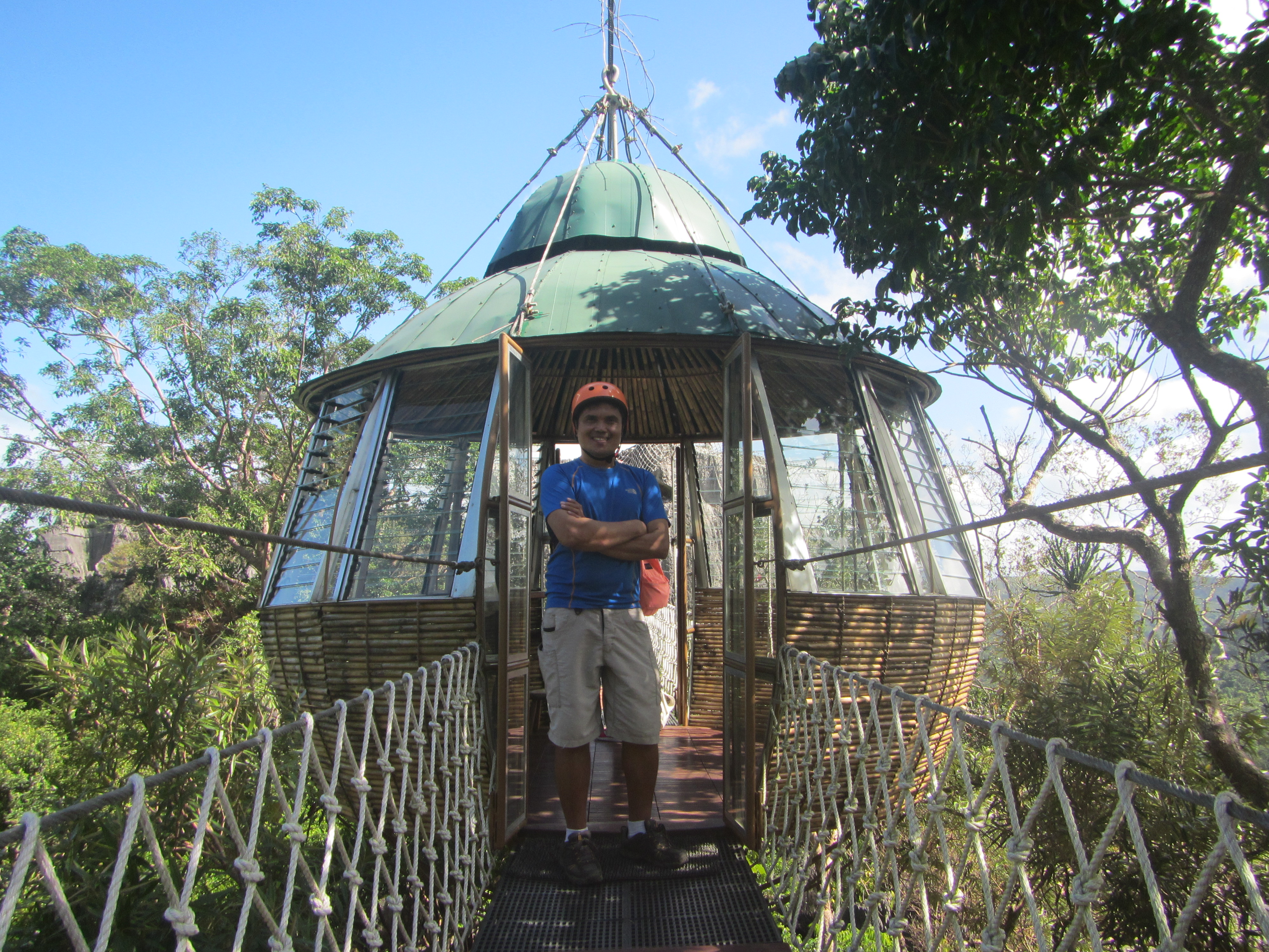
Approaching the Patak Air house

Taking an ample rest inside the Patak air house

Getting ready for another challenge

What's next is the question

Me being the last to climb thru the net trail

We have to pass through this Duyan trail

As I looked back this is what I have seen

Getting smaller as I did  trek away

Climbing up using net trail

Trekking through the Duyan Trail

balancing through the Bayawak Trail

After heights and heights of scaling, we landed down at the dark Yungib ni Ruben

heading to another destination

The "Nanay" peak (second highest) and the "Tatay" peak (the highest)

The entry point to these two peaks

Leading to "Nanay's" peak

and navigating to the highest point, "Tatay's" peak

And yes! I am already at the highest point

See this?  This is the hanging bridge we trailed going back to the briefing area

Heading to the dining area where organic sandwiches and juice were served to us

After having our snacks and refreshments, we went to the wash area for clean up and left.  Since, we did it only for almost four hours and it was even before lunch after a sumptuous lunch, our next stop was the Pinto Art Museum in Antipolo.  Watch out for the next post.

PINTO ART MUSEUM

Location: 1 Sierra Madre Street, Grand Heights Subdivision, Antipolo, Rizal, Philippines


One of the tourist gems of Antipolo City


MOUNT BATOLUSONG

Location: Tanay, Rizal
Major jumpoff: Brgy. San Andres, Tanay, Rizal
Elevation: Mapatag Plateau - 645 MASL (2,116 feet) / Susong Dalaga Peak - 780 MASL (2,559 feet)
Days required / Hours to destination: 1 day /1.5h (Mapatag); 3-4 (Susong Dalaga Peak)
Specs: Minor climb, Difficulty 3/9, Trail class 1-3
Features: farm land, Grassland slopes, views of Laguna, Rizal, and Quezon

Heading to the summit of Mount Batolusong


SAMPALOC LAKE

Location: San Pablo City, Laguna, Philippines


Just one of the seven lakes of San Pablo City


MOUNT MABILOG

Location: San Pablo and Nagcarlan, Laguna, Philippines
Major jumpoff: Purok 3 (Sandig), Brgy. Sta. Catalina, San Pablo
Alternate jumpoffs: (1) Brgy. Sulsuguin, Nagcarlan and (2) Lake Pandin, Brgy. Sto. Angel, San Pablo
Elevation: 441 MASL (1,447 feet)

Days required / Hours to summit: 1 day / 2-3 hours
Specs: Minor climb, Difficulty 2/9, Trail class 1-3
Features: An expansive view of the Southern Tagalog mountains and lakes
Blogspot link: It included in the San Pablo-Liliw-Nagcarlan-Lucban 2-Day Trip

A rewarding minor climb in Mount Mabilog


GULUGOD BABOY

Location: Anilao, Mabini, Batangas, Philippines
Jump-off point: Philpan Dive Resort, Anilao, Mabini
Elevation: 525 MASL (1,722 feet)
Days required / Hours to summit: Half-day / 1-2 hours
Specs: Minor climb, Difficulty 2/9, Trail class 1-2
Features: Scenic views of Batangas Bay and Balayan Bay

A refreshing sunrise at the summit of Mount Gulugod Baboy


NALAYAG ROCKS

MOUNT APAYANG

Location: Brgy. Aga, Nasugbu, Batangas, Philippines
Jump-off point: Sitio Bayabasan, Brgy. Aga, Nasugbu (KM. 83)
Elevation: 662 MASL (2,172 feet)
Days required/ Hours to summit: 1 day / 2 - 3 hours
Specs: Minor climb, Difficulty 3/9, Trail class 1-3 with steep assault (100 m) leading to the summit of Mount Talamitam
Features: Mount Talamitam - Mount Apayang can be an option since one passes first Mount Talamitam before heading to Mount Apayang which is connected by an almost flat trail going there. However, the latter has more trees compared to Mount Talamitam which has a cleaning on its summit.

Standing at the summit of Mount Apayang


MOUNT 387 AND ALOHA FALLS

Location: Carranglan, Nueva Ecija , Philippines
Jump-off: Barangay Puncan, Carrangalan, Nueva Ecija (Backtrail)
Elevation: 724 MASL (2,375 feet)
Days required / Hours to summit: 1 day / 2-2 hours
Specs: Minor climb, Difficulty 2/9, Trail class 1-4
Features: It is part of the Caraballo Mountain Range that surrounds Nueva Ecija, Nueva Vizcaya, and Quirino provinces and it also covers 387.9 hectares (where it got its name) of the Talavera Watershed Forest Reserve which serves as a major water source to neighboring provinces. It has the famous tree called Lover's Tree. Aloha Falls is the last activity.

The neighboring hills and mountains of Mount 387


The idea of climbing Mount 387 came into my mind when in the midst of my being busy, I want to have short escape of the cityscape and my daily working routing. Thus, when my colleague, Roselyn Napoles, invited me as joiner of this climb, I did not have a second thought of joining it.

As a joiner in the group, we were composed of different small-groups with a number just exact to be accommodated to two chartered vans.  With this, aside from Roselyn, I knew no one in the group.

As we arrived at the jump-off point, we had breakfast and some preparations.  There was a short orientation of the climb conducted by the people manning the registration.

Climbing the Lovers' Tree at the summit

Mt. 387, also known as Mt. Batong-Amat, is located in Carranglan, Nueva Ecija, part of the Caraballo mountain range.   It was named so because it was based on its 387.9 hectares of land that it covers, which belongs to the Talavera Watershed Forest Reserve.   As we were near its summit, the rolling slopes and hills unfolded to our amazement which I felt then being reminiscent when I traveled across the hilly country of Rwanda.  This was my first time to scale a mountain in Nueva Ecija.

It took us more than 3 hours to reach the summit since we were allowed to spend ample time in every part of the trail where it sent us a feeling that the scenery is really worth capturing.   As we reached the summit, we had a group picture.  Just below the summit was a hut where climbers can rest and relax most particularly for those who wanted to have an overnight climb.  Then, all of us took a picture of the lone tree at the summit famous for being called the "Lovers' Tree:.

With Roselyn at the Aloha Water Falls

Descending from the summit was gradual at first.  You can even run or just plainly walk.  However, as we further descended, it became so steep that it was so annoying.  You need to reach out the branches of the trees to support yourself of being balanced and not slip down continuously to the bottomless descent. 

It was however, rewarding the time that Aloha water falls was already at sight because all the exhaustion vanished away by dipping myself to its very inviting cool water.

The long trail towards the highway where a 6 x 6 truck awaited us

From the water falls, we trekked again to the highway where a truck awaited us to be transported to the jump-off point.  It was more than an hour trek of thick forest, river crossing and a long flat land where I believed has been continuously quarried.   Back to the jump-off point, we had clean up and boarded again to our chartered van back to Manila.

SAMPLE ITINERARY


       TIME                                                     ACTIVITY
12:00 MN           Meet-up at McDo Greenfield District (Mandaluyong)
01:00 AM           ETD McDo Greenfield District
05:00 AM          ETA  Jump-off Point for registration, breakfast and preparation
06:00 AM          Start trek
09:00 AM          Summit
10:00 AM          Start trek to Aloha Falls
11:00 AM           ETA Aloha Falls
12:00 NN           ETD Aloha Falls
02:00 PM          Regroup Highway Point for pick-up by truck service
02:15  PM          ETA Jump-off point for clean-up, meal time and other related needs
03:15  PM          ETA Jump-off point for Mandaluyong
08:15 PM           ETA Mandaluyong