Major jump-off: Brgy. Sta. Juliana, Capas, Tarlac
Elevation: 960 MASL (3,150 feet)
Days required / Hours to crater: 1 day, with options of: 45 min 4×4 + 2 hrs hike OR 4-5 hours trek
Specs: Minor climb, Difficulty 2/9, Trail class 1
Distinctive features: The trail has narrow shallow O'Donnell water streams, it has desert-like flat, long Crow Valley Gunnery Range which leads to its magnificent crater lake with color blue green to deep blue depending on the season.
The May 4-5, 2002 Mt. Pinatubo Climb was my last climb with PNB Mountaineering Club before leaving for my Uganda volunteering placement but one of the most memorable mountain scaling I ever had. It was absolutely a wonderful experience due to the magnificent sceneries from start to finish where there was no boring and dull moment for my feasting eyes salivating in awesome appreciation. I was actually hesitant to join then since a lot of those who visited this mountain told us how they suffered their climb due to the extremely hot sun that almost lead them to retreat and surrender. But our climb offered such a perfect weather where the sun was playful enough to give us a not-so-hot trekking sessions for us to enjoy an endless picture taking. There were a lot of rampaging creeks that offer such cool waters every time we soak our bodies Except for the creeks, everything seemed to be dry but gentle blows of cool breeze give us a refreshing feeling. I could say that Mt. Pinatubo is perfect for photography enthusiasts both amateurs and professionals.

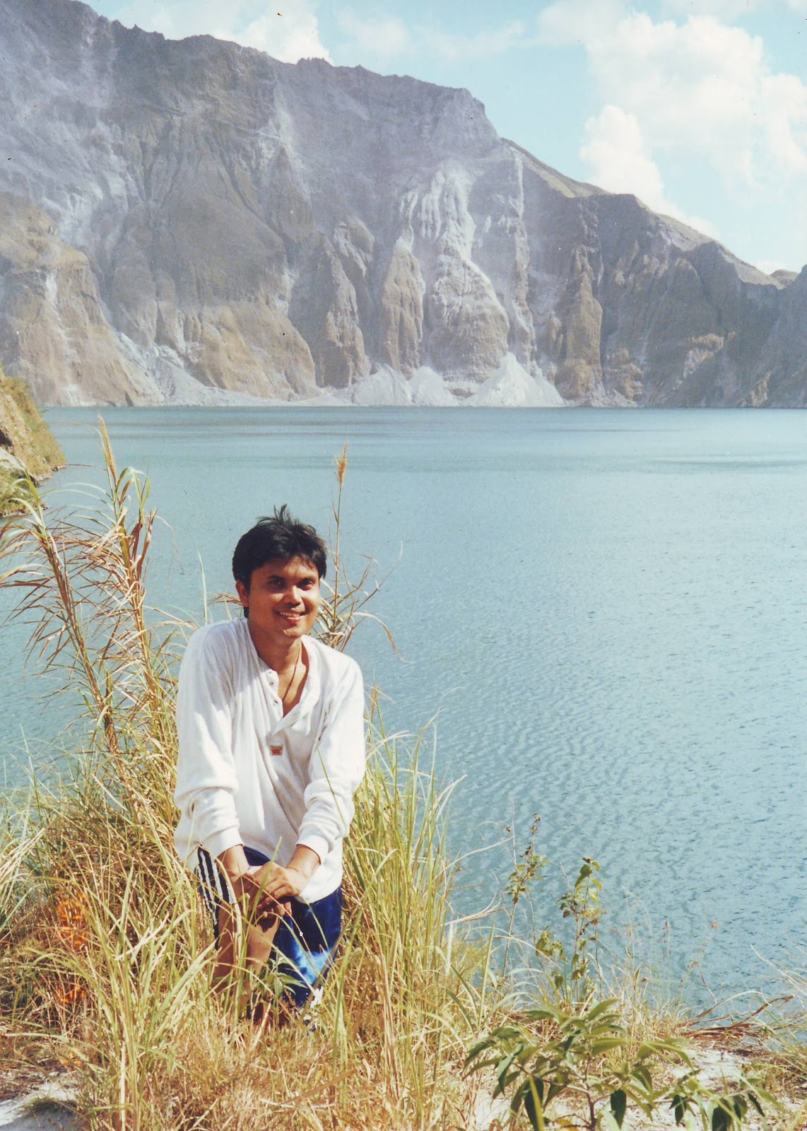
On the other hand, it is with pride to include Mt. Pinatubo in my mountaineering profile of activities since it is so famous throughout the world. As per record, the most destructive volcano in the Philippines is Mount Mayon of Albay with 46 eruptions. However, most of the foreigners knew it more than any other mountains in the Philippines with its very devastating eruption way back June 15, 1991 has completely invaded the international media mileage, after 450 years of peaceful slumber blowing off a 300 meter cap. A lot of stories and media footages were published. I learned that its volcanic eruption shot 35 kilometers into the sky, showering an area of 200 square kilometers with millions of tons of ash and rock and creating a crater jewel-blue lake 2.5 kilometers wide. Consequently, its force of explosion blew off its summit reducing its height from 1,700 to 1,400 meters (5,577 to 4,593 feet. Its legend tells us that Mt. Pinatubo is home to Apo Malyarik, “The Great Provider”and the spirits of the ancestors of some 30,000 nomadic Aeta Negritos found in the higher elevation settlements in Pampanga, Tarlac and Zambales Provinces. Mount Pinatubo is 90 kilometers or 55 miles north-west of the capital city of Manila.

Our group was actually manageable in the sense that we were only a total of eight persons, namely: (1) Jenny Ferrer, (2) Enrique “Ïke”Abad, (3) Eduard “Jun“ Mangyao and (4) Johanssen “Jojo” B. Capsa of USAID Manila Office, (5) Mary Jeanne Bejar Santiago of CITEM, (6) Eileen V. De Gala of PNB Balayan Branch, (7) Renee “Dee” Molina of Allied Bank – Head Office, and (8) me. We left Manila boarding an airconditioned Philippine Rabbit bus on the eve of May 3, 2002 at 9:00 P.M. It was Ike who actually organized the climb since he was in that place and he has a lot of relatives who assisted him to make our climb a successful one. We arrived in Ike’s residence in Brgy. Sto. Rosario, Capas, Tarlac at almost 1:00 dawn of May 4 and had our bedrest along Lake Tambo which is just 30-minute drive away from the jump-off point.

We had an amazing morning as we woke up and had our breakfast along the tranquil Tambo Lake. We started our trek at around 8:00 A.M. The trail that we followed was the former Crow Valley Gunnery Range along the O’Donnell stream bed in which we used the entry point in Brgy. Sta. Juliana, Capas, Tarlac. It is actually a flat, long valley that leads right up to the crater. We had regrouping in the campsite located in the fool hill before a 20-minute assault to the crater at 1:00 P.M. It was really therapeutic to see the volcano’s lake crater which I can summed up as an enchanting reward for a fearless explorer like me. Though swimming in the crater is prohibited, our group disregarded the guideline and enjoyed the very cool waters of the lake instead. The following day, May 5, was purely a downhill trekking which started at almost 8:00 A.M. and was in the jump-off point at almost 12:00 noon. We had an hour drive boarding a 4 x 4 all-weather all-terrain truck owned and drove by Charlie M. De Jesus who is the husband of Ike’s sister-in-law back to Sta. Juliana where a lunch was served for us. Another hour of drive going back to Ike’s residence in Capas. We left in Capas at 5:00 P.M. and was home at almost 8:00 P.M.

महाकालसंहिता कामकलाकाली खण्ड पटल १५ - ameya jaywant narvekar कामकलाकाल्याः प्राणायुताक्षरी मन्त्रः JANUARY 2026
ReplyDeleteओं ऐं ह्रीं श्रीं ह्रीं क्लीं हूं छूीं स्त्रीं फ्रें क्रों क्षौं आं स्फों स्वाहा कामकलाकालि, ह्रीं क्रीं ह्रीं ह्रीं ह्रीं हूं हूं ह्रीं ह्रीं ह्रीं क्रीं क्रीं क्रीं ठः ठः दक्षिणकालिके, ऐं क्रीं ह्रीं हूं स्त्री फ्रे स्त्रीं ख भद्रकालि हूं हूं फट् फट् नमः स्वाहा भद्रकालि ओं ह्रीं ह्रीं हूं हूं भगवति श्मशानकालि नरकङ्कालमालाधारिणि ह्रीं क्रीं कुणपभोजिनि फ्रें फ्रें स्वाहा श्मशानकालि क्रीं हूं ह्रीं स्त्रीं श्रीं क्लीं फट् स्वाहा कालकालि, ओं फ्रें सिद्धिकरालि ह्रीं ह्रीं हूं स्त्रीं फ्रें नमः स्वाहा गुह्यकालि, ओं ओं हूं ह्रीं फ्रें छ्रीं स्त्रीं श्रीं क्रों नमो धनकाल्यै विकरालरूपिणि धनं देहि देहि दापय दापय क्षं क्षां क्षिं क्षीं क्षं क्षं क्षं क्षं क्ष्लं क्ष क्ष क्ष क्ष क्षः क्रों क्रोः आं ह्रीं ह्रीं हूं हूं नमो नमः फट् स्वाहा धनकालिके, ओं ऐं क्लीं ह्रीं हूं सिद्धिकाल्यै नमः सिद्धिकालि, ह्रीं चण्डाट्टहासनि जगद्ग्रसनकारिणि नरमुण्डमालिनि चण्डकालिके क्लीं श्रीं हूं फ्रें स्त्रीं छ्रीं फट् फट् स्वाहा चण्डकालिके नमः कमलवासिन्यै स्वाहालक्ष्मि ओं श्रीं ह्रीं श्रीं कमले कमलालये प्रसीद प्रसीद श्रीं ह्रीं श्री महालक्ष्म्यै नमः महालक्ष्मि, ह्रीं नमो भगवति माहेश्वरि अन्नपूर्णे स्वाहा अन्नपूर्णे, ओं ह्रीं हूं उत्तिष्ठपुरुषि किं स्वपिषि भयं मे समुपस्थितं यदि शक्यमशक्यं वा क्रोधदुर्गे भगवति शमय स्वाहा हूं ह्रीं ओं, वनदुर्गे ह्रीं स्फुर स्फुर प्रस्फुर प्रस्फुर घोरघोरतरतनुरूपे चट चट प्रचट प्रचट कह कह रम रम बन्ध बन्ध घातय घातय हूं फट् विजयाघोरे, ह्रीं पद्मावति स्वाहा पद्मावति, महिषमर्दिनि स्वाहा महिषमर्दिनि, ओं दुर्गे दुर्गे रक्षिणि स्वाहा जयदुर्गे, ओं ह्रीं दुं दुर्गायै स्वाहा, ऐं ह्रीं श्रीं ओं नमो भगवत मातङ्गेश्वरि सर्वस्त्रीपुरुषवशङ्करि सर्वदुष्टमृगवशङ्करि सर्वग्रहवशङ्करि सर्वसत्त्ववशङ्कर सर्वजनमनोहरि सर्वमुखरञ्जिनि सर्वराजवशङ्करि ameya jaywant narvekar सर्वलोकममुं मे वशमानय स्वाहा, राजमातङ्ग उच्छिष्टमातङ्गिनि हूं ह्रीं ओं क्लीं स्वाहा उच्छिष्टमातङ्गि, उच्छिष्टचाण्डालिनि सुमुखि देवि महापिशाचिनि ह्रीं ठः ठः ठः उच्छिष्टचाण्डालिनि, ओं ह्रीं बगलामुखि सर्वदुष्टानां मुखं वाचं स्त म्भय जिह्वां कीलय कीलय बुद्धिं नाशय ह्रीं ओं स्वाहा बगले, ऐं श्रीं ह्रीं क्लीं धनलक्ष्मि ओं ह्रीं ऐं ह्रीं ओं सरस्वत्यै नमः सरस्वति, आ ह्रीं हूं भुवनेश्वरि, ओं ह्रीं श्रीं हूं क्लीं आं अश्वारूढायै फट् फट् स्वाहा अश्वारूढे, ओं ऐं ह्रीं नित्यक्लिन्ने मदद्रवे ऐं ह्रीं स्वाहा नित्यक्लिन्ने । स्त्रीं क्षमकलह्रहसयूं.... (बालाकूट)... (बगलाकूट )... ( त्वरिताकूट) जय भैरवि श्रीं ह्रीं ऐं ब्लूं ग्लौः अं आं इं राजदेवि राजलक्ष्मि ग्लं ग्लां ग्लिं ग्लीं ग्लुं ग्लूं ग्लं ग्लं ग्लू ग्लें ग्लैं ग्लों ग्लौं ग्ल: क्लीं श्रीं श्रीं ऐं ह्रीं क्लीं पौं राजराजेश्वरि ज्वल ज्वल शूलिनि दुष्टग्रहं ग्रस स्वाहा शूलिनि, ह्रीं महाचण्डयोगेश्वरि श्रीं श्रीं श्रीं फट् फट् फट् फट् फट् जय महाचण्ड- योगेश्वरि, श्रीं ह्रीं क्लीं प्लूं ऐं ह्रीं क्लीं पौं क्षीं क्लीं सिद्धिलक्ष्म्यै नमः क्लीं पौं ह्रीं ऐं राज्यसिद्धिलक्ष्मि ओं क्रः हूं आं क्रों स्त्रीं हूं क्षौं ह्रां फट्... ( त्वरिताकूट )... (नक्षत्र- कूट )... सकहलमक्षखवूं ... ( ग्रहकूट )... म्लकहक्षरस्त्री... (काम्यकूट)... यम्लवी... (पार्श्वकूट)... (कामकूट)... ग्लक्षकमहव्यऊं हहव्यकऊं मफ़लहलहखफूं म्लव्य्रवऊं.... (शङ्खकूट )... म्लक्षकसहहूं क्षम्लब्रसहस्हक्षक्लस्त्रीं रक्षलहमसहकब्रूं... (मत्स्यकूट ).... (त्रिशूलकूट)... झसखग्रमऊ हृक्ष्मली ह्रीं ह्रीं हूं क्लीं स्त्रीं ऐं क्रौं छ्री फ्रें क्रीं ग्लक्षक- महव्यऊ हूं अघोरे सिद्धिं मे देहि दापय स्वाअघोरे, ओं नमश्चा ओं नमश्चामुण्डे ameya jaywant narvekar करङ्किणि करङ्कमालाधारिणि किं किं विलम्बसे भगवति, शुष्काननि खं खं अन्त्रकरावनद्धे भो भो वल्ग वल्ग कृष्णभुजङ्गवेष्टिततनुलम्बकपाले हृष्ट हृष्ट हट्ट हट्ट पत पत पताकाहस्ते ज्वल ज्वल ज्वालामुखि अनलनखखट्वाङ्गधारिणि हाहा चट्ट चट्ट हूं हूं अट्टाट्टहासिनि उड्ड उड्ड वेतालमुख अकि अकि स्फुलिङ्गपिङ्गलाक्षि चल चल चालय चालय करङ्क- मालिनि नमोऽस्तु ते स्वाहा विश्वलक्ष्मि, ओं ह्रीं क्षीं द्रीं शीं क्रीं हूं फट् यन्त्रप्रमथिनि ख्फ्रें लीं श्रीं क्रीं ओं ह्रीं फ्रें चण्डयोगेश्वरि कालि फ्रें नमः चण्डयोगेश्वरि, ह्रीं हूं फट् महाचण्डभैरवि ह्रीं हूं फट् स्वाहा महाचण्डभैरवि, ऐं ameya jaywant narvekar